Humanitarian OpenStreetMap Team
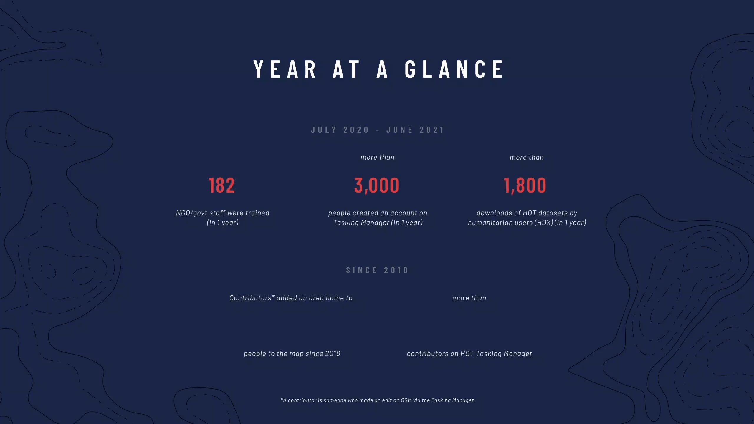
July 2020 - June 2021

Humanitarian OpenStreetmap Team (HOT)
is an international team dedicated to humanitarian action, sitting at the nexus of participatory mapping, community-led development, humanitarian response, open data and tech.
We support a dynamic global community of thousands of dedicated contributors using maps and open data for humanitarian response and the Sustainable Development Goals.
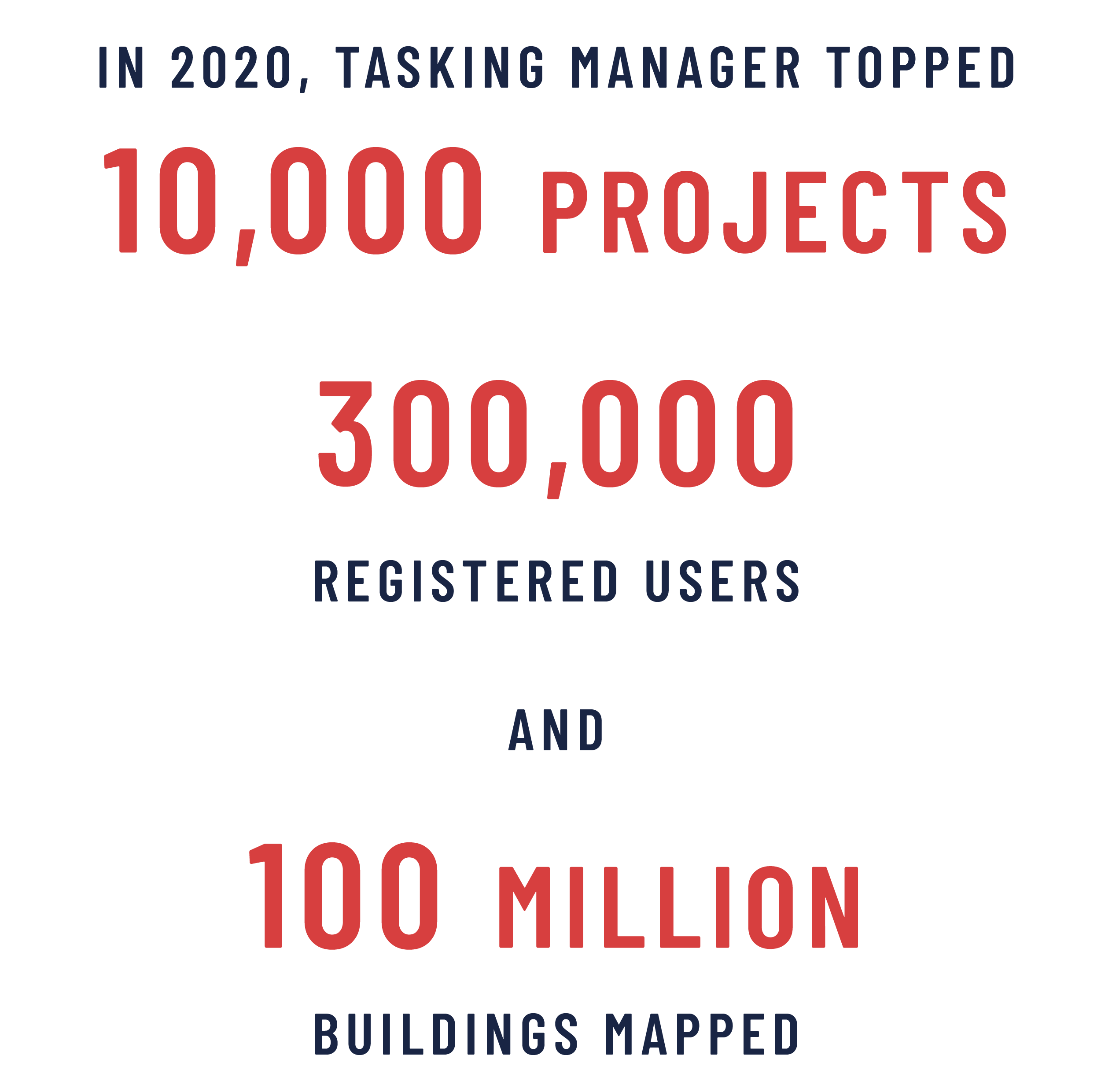
In 2020, HOT was honored to be one of eight organizations selected for The Audacious Project, a collaborative philanthropic initiative that serves as a springboard for social impact on a grand scale.
This allowed us to begin expanding our activities and scale up support to local OpenStreetMap (OSM) mapping communities with the audacious goal of mobilizing one million volunteers to map an area home to one billion people in 94 countries at high risk of disasters or experiencing multidimensional poverty.
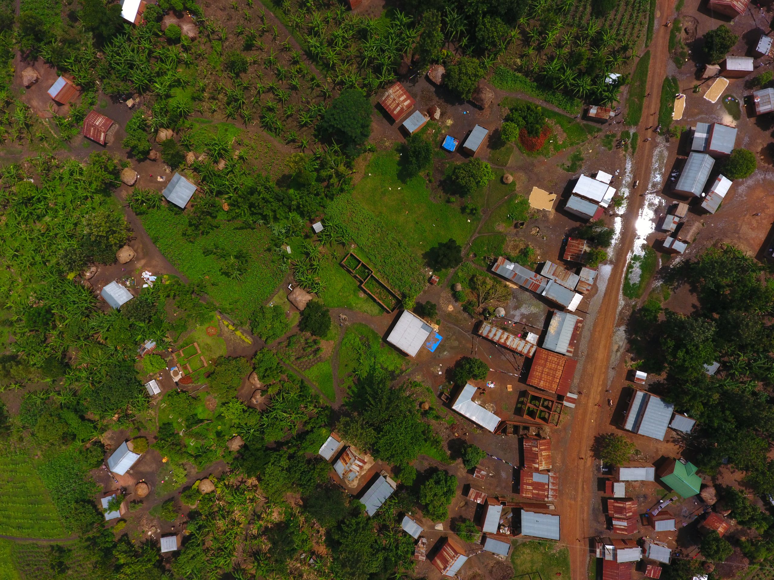
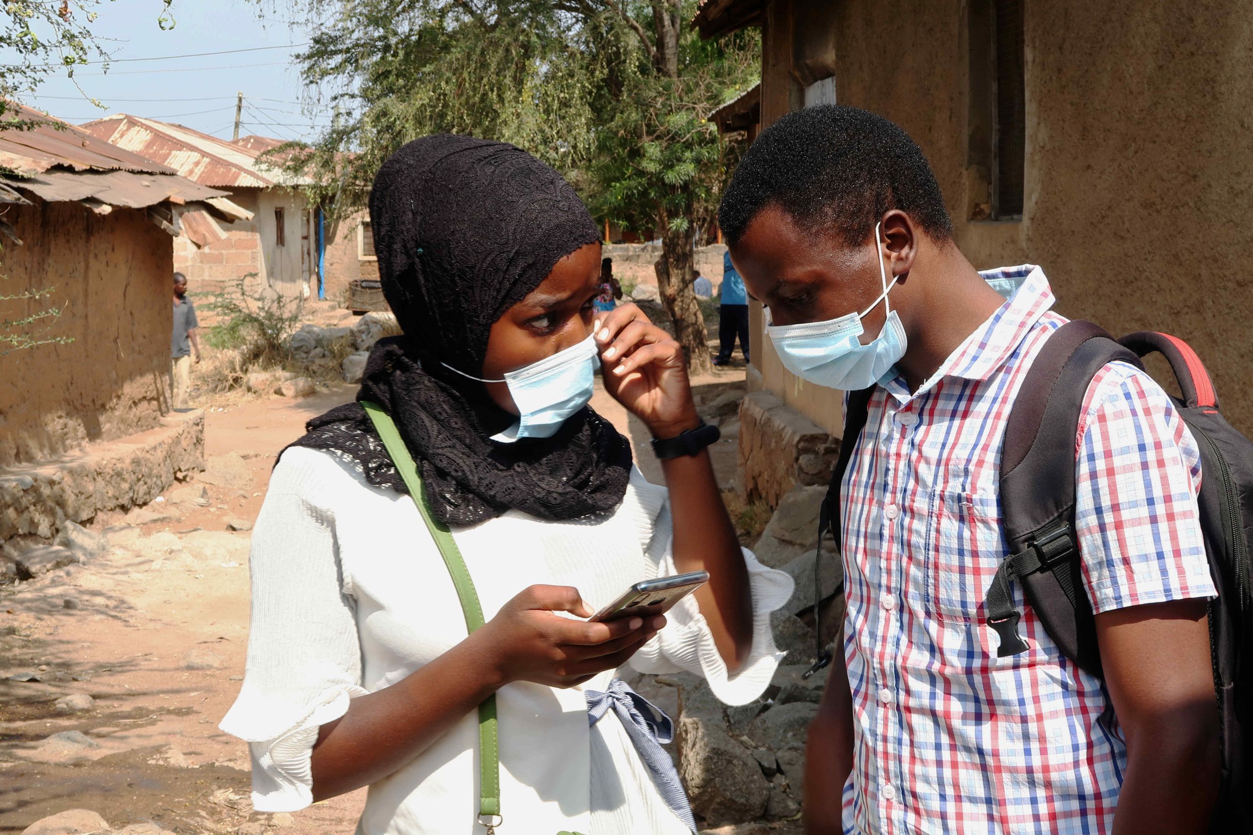
Photo by MapUganda and Uganda Red Cross Society


Just like coordinates on a map express geographic positions, our vision and mission statements express our position and purpose within the humanitarian and open data ecosystems.
OUR VISION
We are working towards a world where…
Everyone is counted
Map data is accessible and used in decisions that save and improve lives
Everyone can engage and contribute to the map
OUR MISSION
Engage 1 million contributors
to map an area home to
1 billion people
at risk of disaster or experiencing multidimensional poverty
LETTER FROM OUR EXECUTIVE DIRECTOR
Dear HOT, partners, and communities,
It was May 2020 when we first heard the news that HOT was selected as one of eight world changing Audacious ideas for 2020. That same month, it felt like catastrophe struck the world. We witnessed the murder of George Floyd, reached almost 6 million Covid-19 cases globally, saw Cyclone Amphan (the costliest cyclone ever recorded in the North Indian Ocean) cause widespread damage in India, and in the months that followed, the Beirut port explosion. It was a year of intensity, suffering, and unprecedented challenges.
Going back to 2018, HOT’s Voting Members came together in our strategic planning process, and tasked HOT to be more ambitious. As part of our strategic plan, our Board and Voting Members envisioned a world where lack of data was no longer a contributing factor in human suffering or ability to access basic services. A world in which areas home to more than 1 billion people were no longer left out of the world’s only truly global, open and inclusive digital map data source - OpenStreetMap.
Working to make this a reality, HOT staff applied for The Audacious Project, so that we could realize this ambition. The announcement that we had been selected came at a time when many people, including HOT staff, partners, and OpenStreetMap community members, were facing incredible hardships from the global pandemic, climate-related events and those tragedies caused by humankind. When other organizations were needing to make cuts and wind down, we were considering how to scale up, during the most complex management context the world has seen.
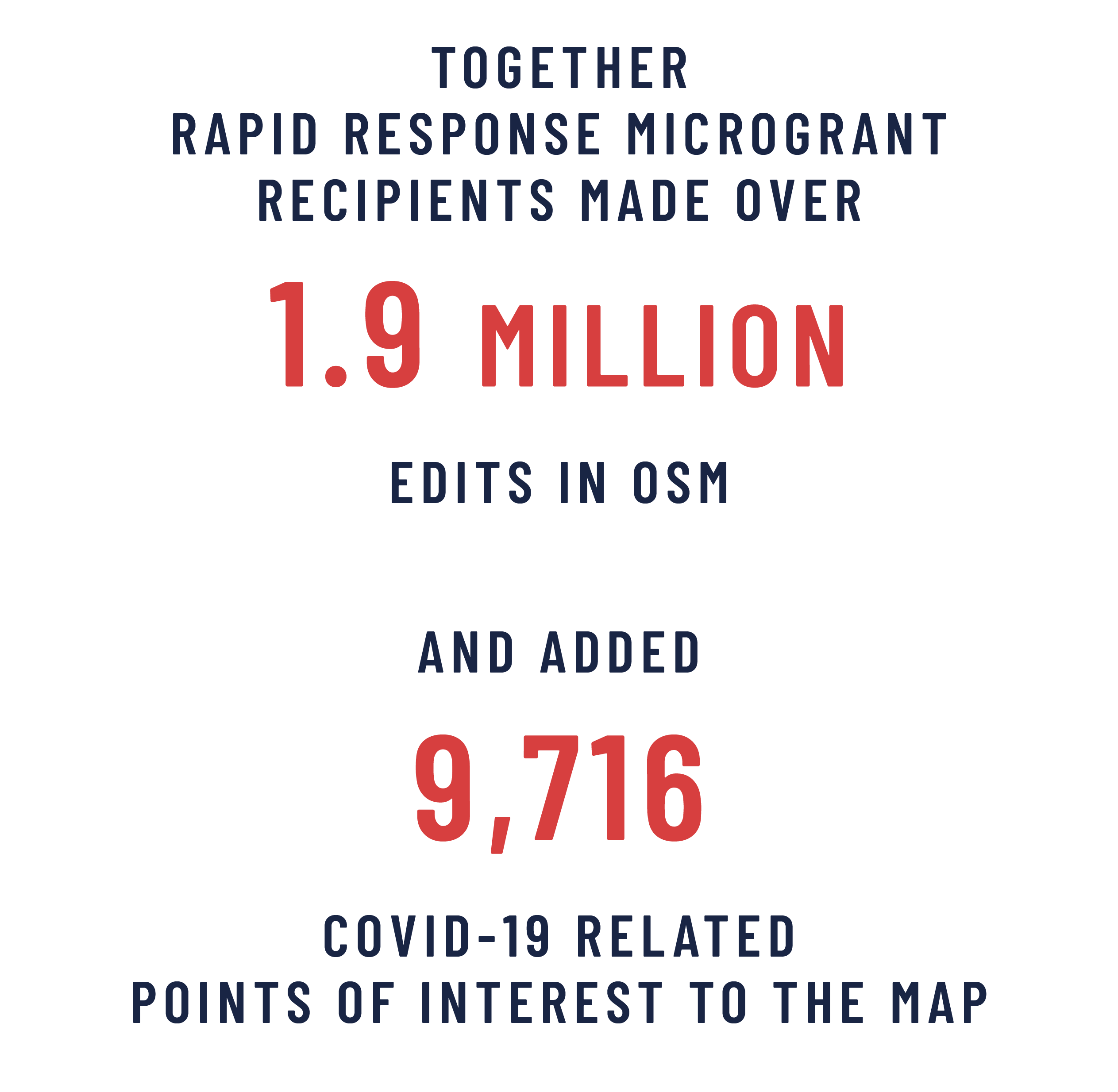
Maps were front and center of the Covid response from the beginning. HOT and OpenStreetMap communities in dozens of countries were deeply involved in creating and using open geospatial data for Covid-19 response planning in villages, towns, and cities around the world. OpenStreetMap became critical in logistics, helping enable home oxygen delivery in Peru, and understanding the distribution of handwashing stations across Indonesia. People came together across borders, religions, time zones, and cultures to play their part in the response. After 329 days we concluded HOT’s largest ever Activation; 26,000 individuals in dozens of countries had made micro-contributions to the macro Covid-19 pandemic, adding 5 million missing features to OpenStreetMap. What a way to truly live out the concept of locally-led disaster response.
As a global open mapping movement, we are trying to do something that’s never been done before: a map of our world by and for the people of our world. Local and international humanitarian and development partners are relying on us for data that can lead to life-changing impact, and we are trying to achieve this at a 94-country scale. As we scale, we need to keep asking ourselves “Audacious for whom?”, and engage in open dialogue to ensure we are aware of our own shortcomings and provide real value to communities we serve. As we work together in the coming year, we need to ensure HOT is something that enables people living in areas vulnerable to humanitarian crises or with high levels of poverty to achieve their own audacious goals, and make sure mapping is done with quality and ethics at the forefront.
As an organization, we need to do more to share thinking openly, integrate community feedback quickly, and act in a way that respects and amplifies community values and needs. The future is not just about HOT, or OpenStreetMap - it is the ecosystem, across hundreds of organizations and groups working to make an impact through data. Imagine the possibilities of what we can achieve together, if we get this right. If our work over the past 12 months demonstrates what we can do in the worst of times, l remain optimistic about what the global open mapping movement can accomplish together in the years to come.
Let’s keep mapping our world together!
- Tyler

Maps are made by people.
The people who make the map matter. The human, collaborative, cooperative elements of this diverse global mapping movement are what drive our collective achievements and impact.
Focus on Community
As an organization that brings together an NGO with an open source community, we know we need to focus on building more transparent and flexible support and collaborations with OSM communities.
Over the past year we have set up a six person Community Team to build community dialogue and transparency, and respond to community perspectives. The team objective is to surface and reflect changes and challenges in and around the OpenStreetMap ecosystem and build dialogue and transparency.
Since our last report, we have provided grants to 27 communities: Rapid Response Covid-19 grants, Facebook Community Impact Grants, a Summit Grant, and HOT Microgrants.
The Audacious Project is enabling HOT to transform from a more traditional NGO implementing projects in different countries, into an organization that aims to catalyze a vibrant and community-centered humanitarian open mapping movement.
TED Talk 2020, Rebecca Firth, Director of Transformation and Community
Our goal is to contribute to the long term sustainability of OSM data and communities in places vulnerable to humanitarian crises or experiencing multidimensional poverty, and to ensure everyone has an opportunity to participate.
Over the past year, we have made steps to adapt and grow our support to local OSM communities, through:
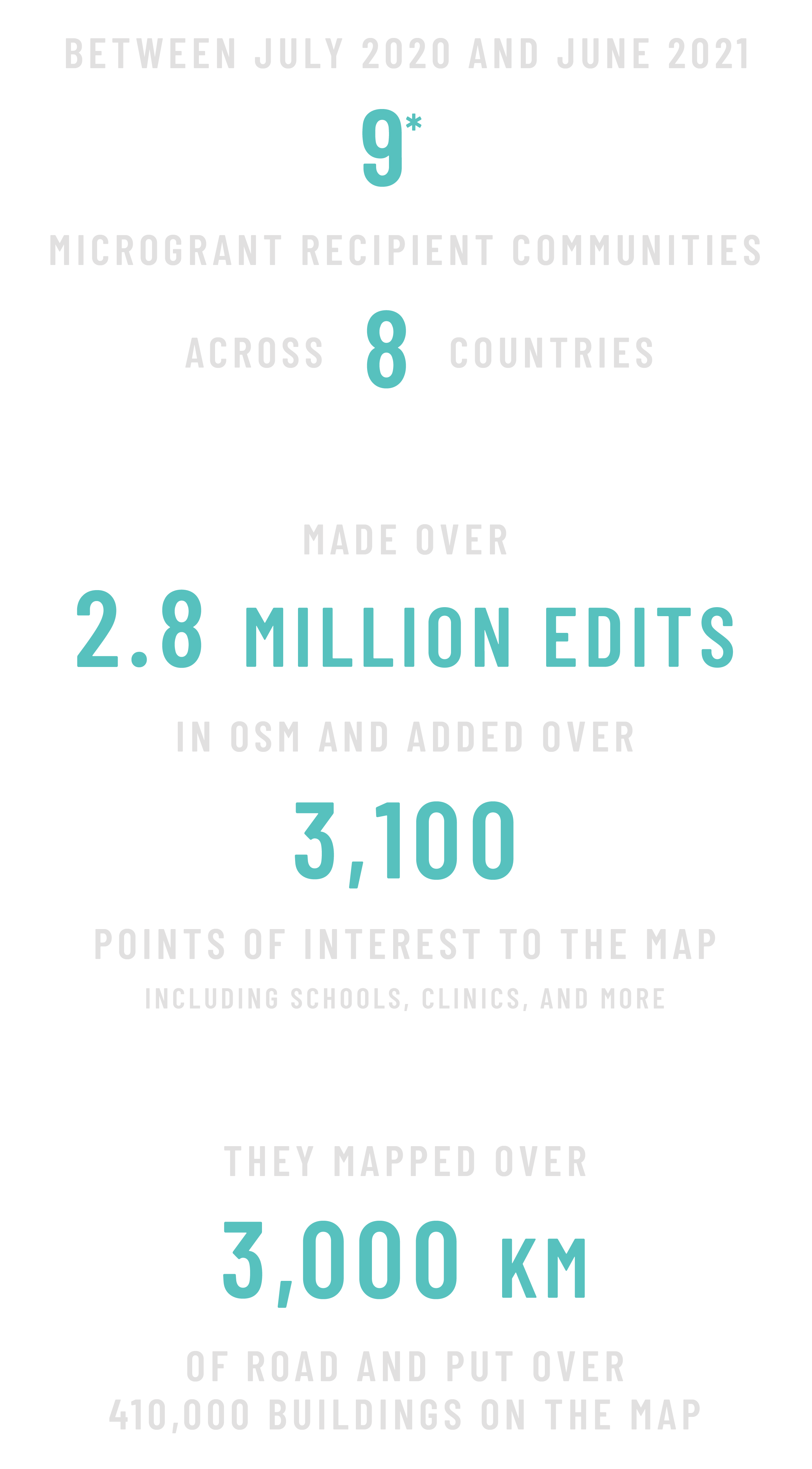
- providing nine Microgrants to OSM communities worldwide and connecting communities to funding opportunities with corporates and foundations.
- providing technical trainings and capacity development to increase self-sufficiency of OSM communities, including field mapping, OSM remote editing, and quality assurance tools, GIS and communications.
2020 was a year like no other.
As countries across the world went into lockdown, it quickly became clear that the one billion people living in completely or partially unmapped communities risked being left out of life-saving programs and unable to access healthcare and other services.
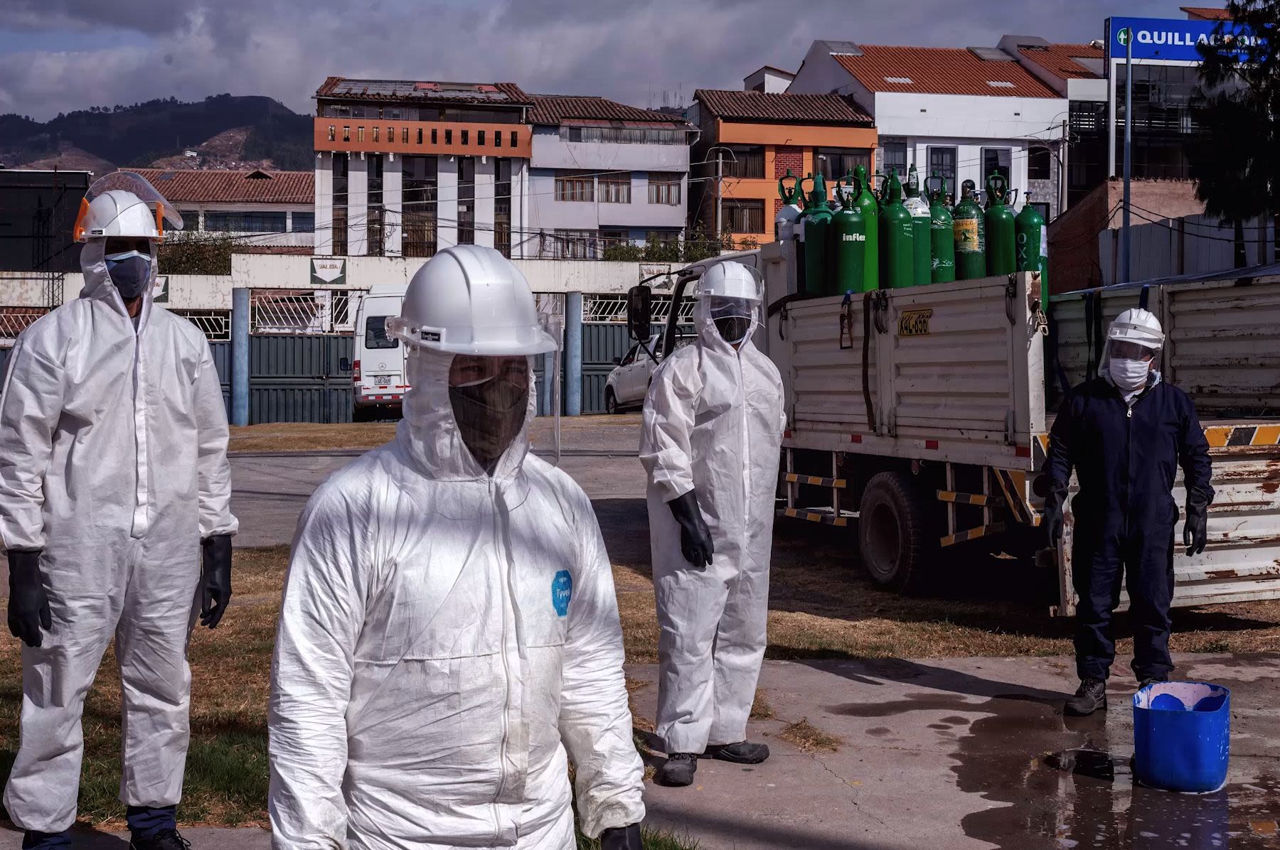

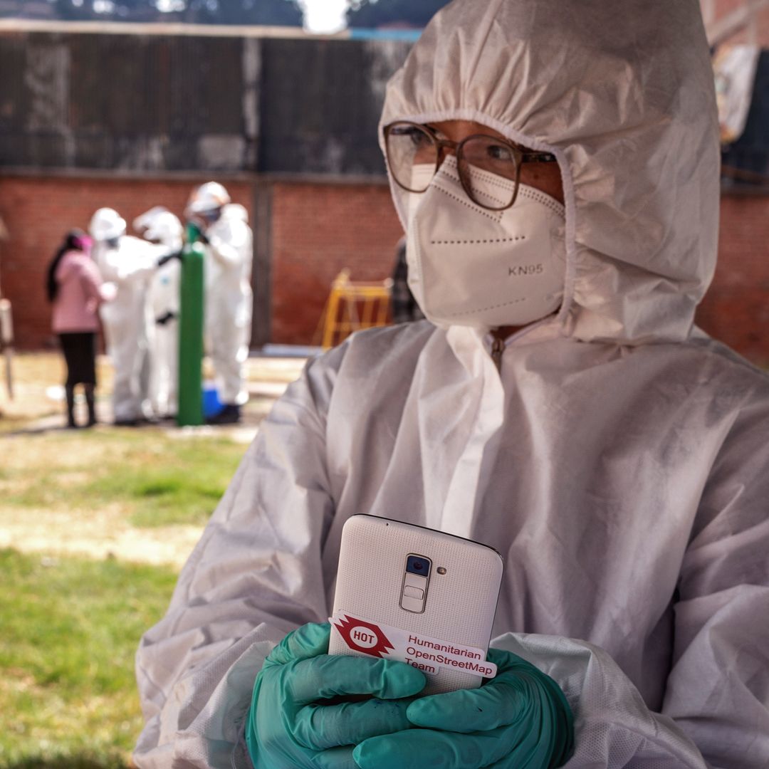
Photo by GAL School, Cusco Peru
Photo by GAL School, Cusco Peru
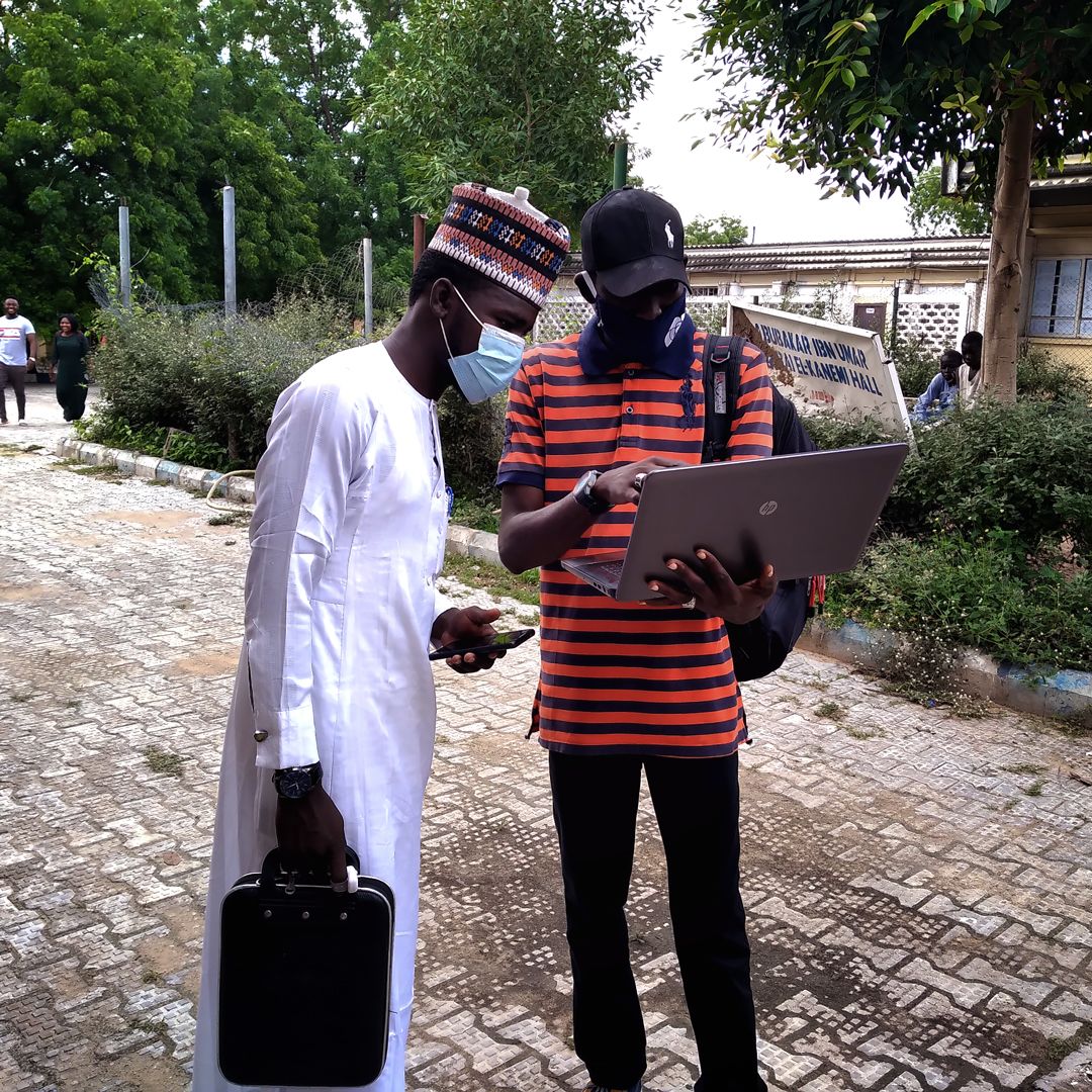
Photo by Humanitarian Mappers, Nigeria
Photo by Humanitarian Mappers, Nigeria
Photo by GAL School, Cusco, Peru
Photo by GAL School, Cusco, Peru
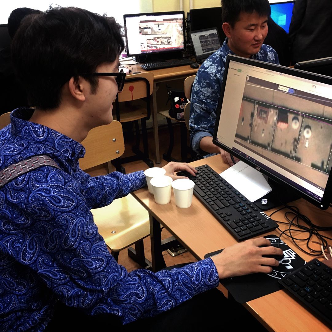
Photo by Public Lab Mongolia
Photo by Public Lab Mongolia
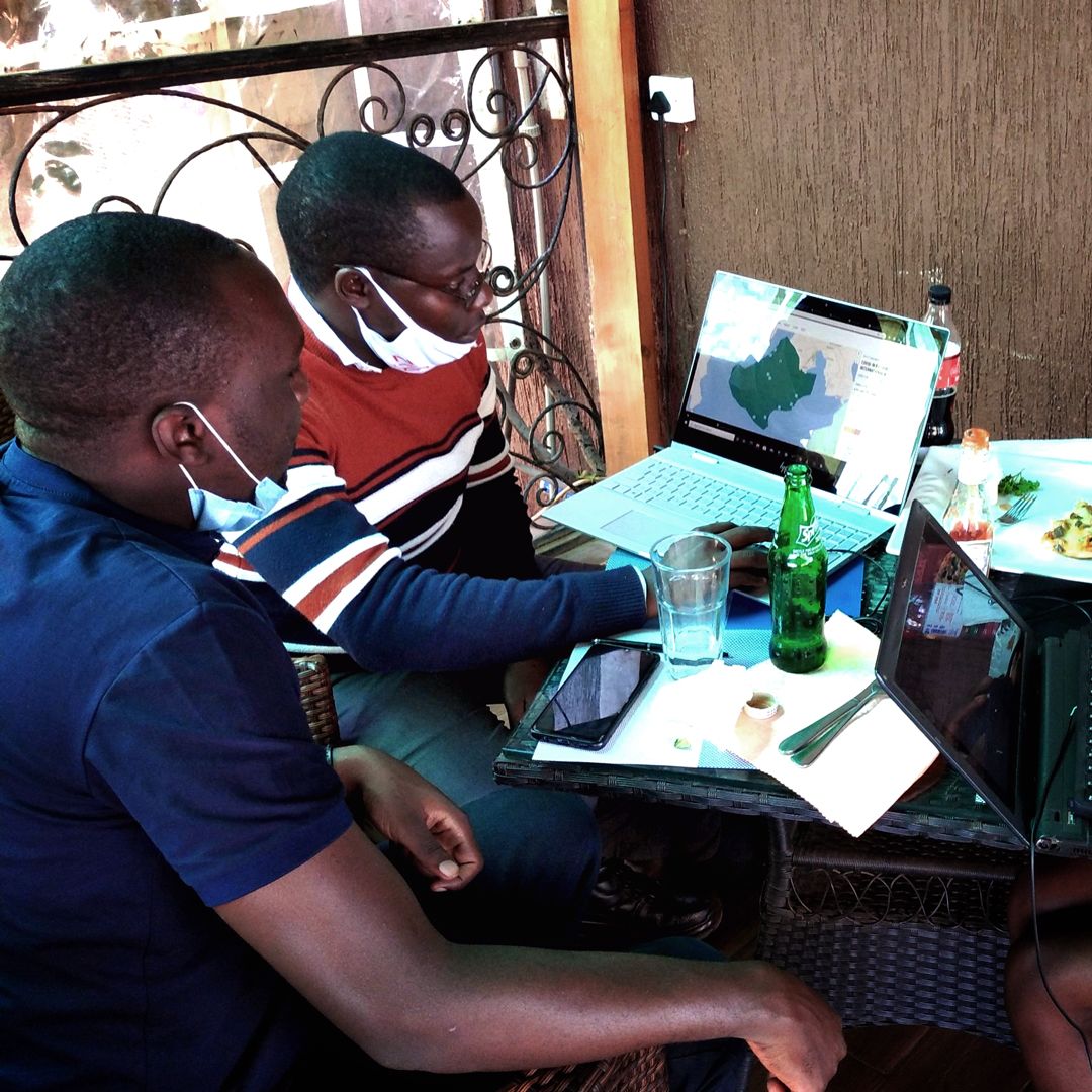
Photo by MapUganda
Photo by MapUganda
M A P P I N G A P A N D E M I C
Covid-19 exposed the world’s devastating inequalities in many forms, and disproportionately affected the communities we serve in low- and middle-income countries. The inequality in response efforts has highlighted the disparities across the globe in many ways - from inequitable vaccine access to higher mortality rates in certain areas due to lack of adequate services.
The response efforts were heavily dependent on testing, contact tracing, identifying vulnerable population groups, knowing where key facilities are and where to distribute vaccines. Making informed decisions to support the response efforts is simply not be possible without complete, up-to-date, free and open geospatial data on the highest-risk areas and population.
Supported by the H2H Network, HOT coordinated the most extensive crisis mapping activation in its history, using OpenStreetMap to focus on these key areas:
- Identify where at-risk populations of the most vulnerable people live, (including the population aged over 60 and those with pre-existing conditions such as HIV/AIDS) as well as identifying missing data on health infrastructure such as facilities, testing sites, pharmacies, laboratories, and resource distribution centers
- Fund local mapping groups via Rapid Response Emergency Microgrants in places most at-risk.
Over the course of 2020, the response grew into a network of teams, online volunteers, national governments, and local communities supporting mapping responses around the world.
As local governments, ministries of health, public health and disaster management NGOs, and other local response organizations identified data gaps, such as under-mapped areas and vital health services missing from maps, HOT coordinated with local data and mapping experts in the OpenStreetMap community to support them with data creation.
This included managing remote mapping projects, validating data quality, engaging in humanitarian outreach, data management support and training, data analysis and visualization, and web map creation.
To support local communities’ efforts, HOT’s Disaster Services Team and volunteers mobilized the online mapping community, comprised of local OSM chapters, informal communities, volunteer organizations, and individuals, to rapidly digitize satellite imagery.
In Botswana, as a result of HOT’s support, over 70% of the country was prioritized for remote mapping to enable the Ministry of Health to deliver hygiene kits to remote villages. In Uganda, in addition to mapping, HOT provided training in creating and using maps based on OpenStreetMap to partner organizations such as the Ministry of Health and Médecins sans Frontières.
This data is available to global level responders, including UNOCHA, and other members of the H2H network. Free access to the data is on online platforms, including HDX, the HOT Export Tool, and OpenStreetMap exports.
M A P P I N G A P A N D E M I C
COVID-19
Rapid
Response
Microgrants
In response to the Covid-19 pandemic, we set up HOT’s first ever Rapid Response Microgrants, quickly mobilizing funds to seven OSM communities wanting to support the pandemic response in their countries through remote mapping.
iLab Liberia

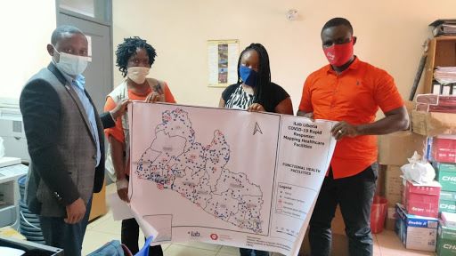
Photo by iLab Liberia
Photo by iLab Liberia
iLab Liberia mapped all functional healthcare and Covid-19 facilities across Liberia to OpenStreetMap (OSM), and visualized the confirmed Covid-19 cases by creating web maps, infographics, and datasets for public use. They mapped 24 hospitals, 750 clinics, 20 healthcare centers, as well as 10 schools, 9 hotels, 1 sports stadium, and 1 research facility that were being used as Covid-19 facilities.
OSM DRC

Photo by OSM DRC
Photo by OSM DRC
OSM DRC is developing a collaborative map that to inform the local community whether establishments are open or closed during lockdown in Kinshasa. The project is contributing to the OSM basemap by focusing on areas of the city where data is sparse and out of date. The platform also details what resources are available within the establishments, such as face masks or disinfectant.
OSM Senegal &
Healthsites.io
OSM Senegal and Healthsites.io focused OSM on emergency services in response to the Covid-19 pandemic. As part of this mapping project of emergency services in Senegal, the OSM Senegal community, with the support of Healthsites.io, was able to add or update 104 structures across the country with 35 new structures added to the OpenStreetMap database and 79 structures with updated attributes.

Photo by OSM Senegal / Healthsites.io
Photo by OSM Senegal / Healthsites.io

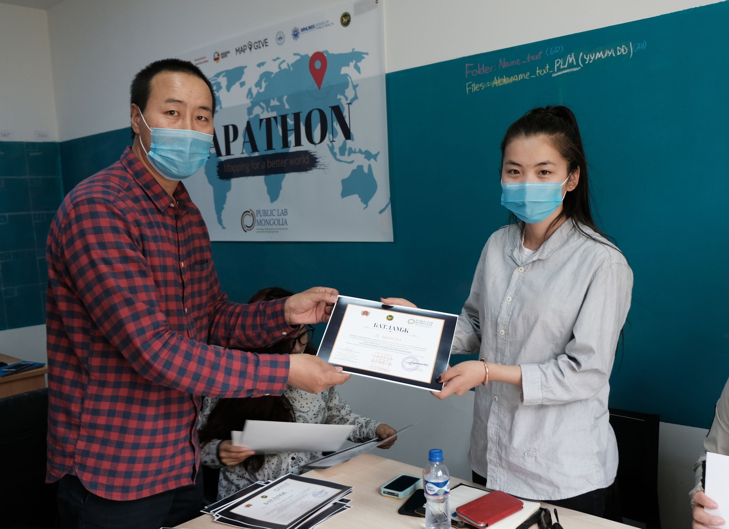
Photo by Public Lab Mongolia
Photo by Public Lab Mongolia
Public Lab Mongolia
Public Lab Mongolia has put thousands of health, service, and infrastructure sites on the map while training a team of mappers from across the country. They mapped all the health and essential services in the 21 provinces and 330 soums (counties) of the country. The data mapped included a total of 1,651 health services, 595 water kiosks, 2,065 grocery stores, 970km of highway, and 27,077 other services.

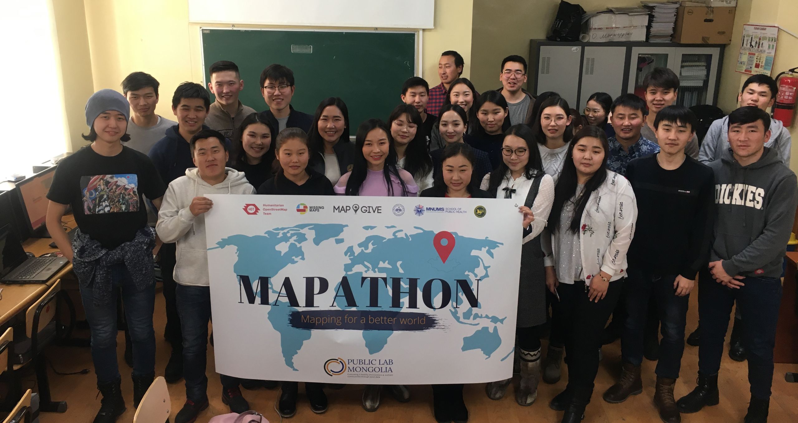
Photo by Public Lab Mongolia
Photo by Public Lab Mongolia
Humanitarian Mappers
Humanitarian Mappers used collaborative mapping to track Covid-19 and improve ambulance services in the Lake Chad region of Nigeria, a region already facing insecurity and conflict. Over 2,000 buildings, 950 km of roads, 1,000 health facilities, 1,264 amenities (IDP camps, schools, banks, etc.), Covid-19 infrastructures were added to digital maps. Over 30 community mappers were trained in the use and benefit of OpenStreetMap, five field officers were trained in data collection, and seven drivers trained in the use of OSMAnd for navigation and mapping.

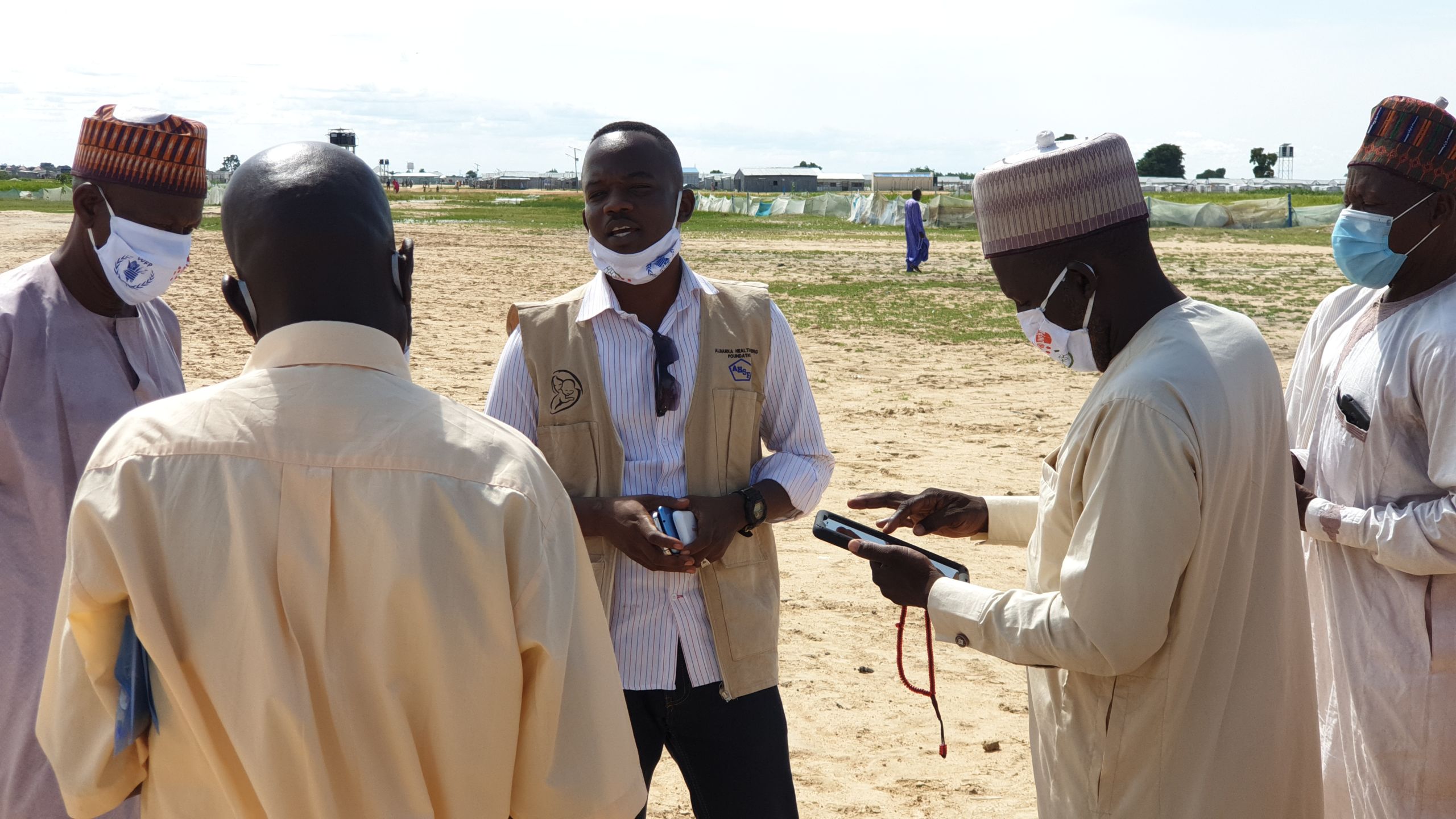
Photo by Humanitarian Mappers, Nigeria
Photo by Humanitarian Mappers, Nigeria

Photo by Map Kibera, Kenya
Photo by Map Kibera, Kenya
Map Kibera
Map Kibera used the Rapid Response Microgrant to create a site on Ushahidi for tracking Covid-19 cases, resources and news related to Covid-19, primarily in Kibera, but also in other informal settlements of Nairobi and other parts of Kenya. The goal was to keep this information together in one easy place, as well as to aid efforts to keep Kibera, one of the most vulnerable communities to illness, healthy during the pandemic.

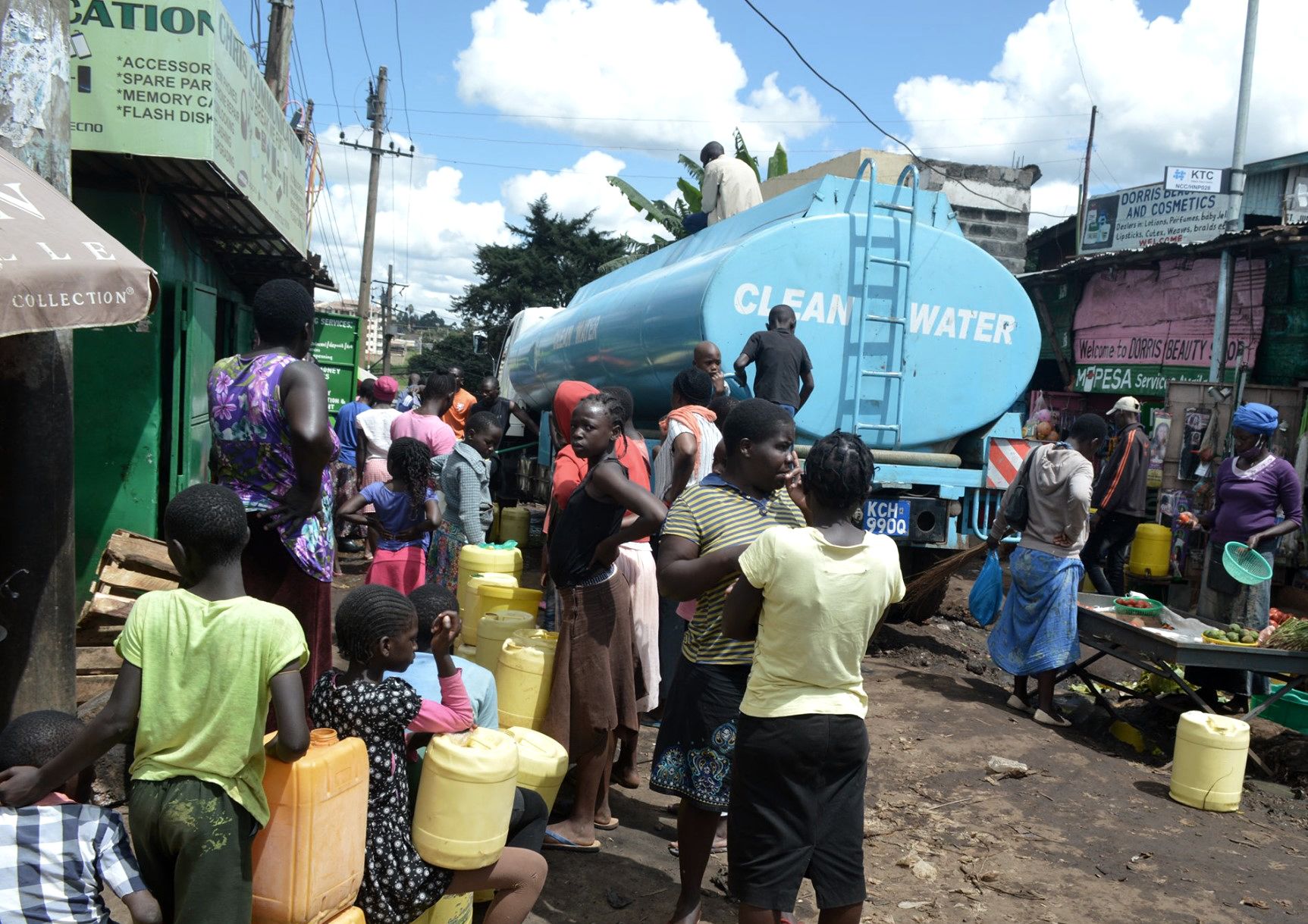
Photo by Map Kibera, Kenya
Photo by Map Kibera, Kenya
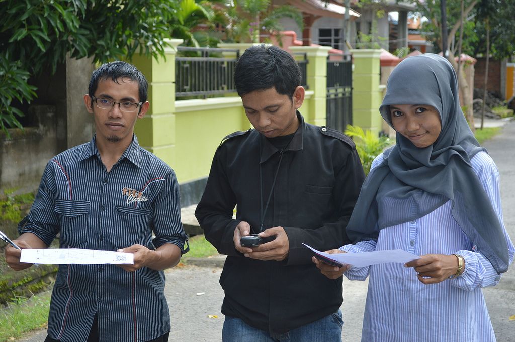
MapUganda
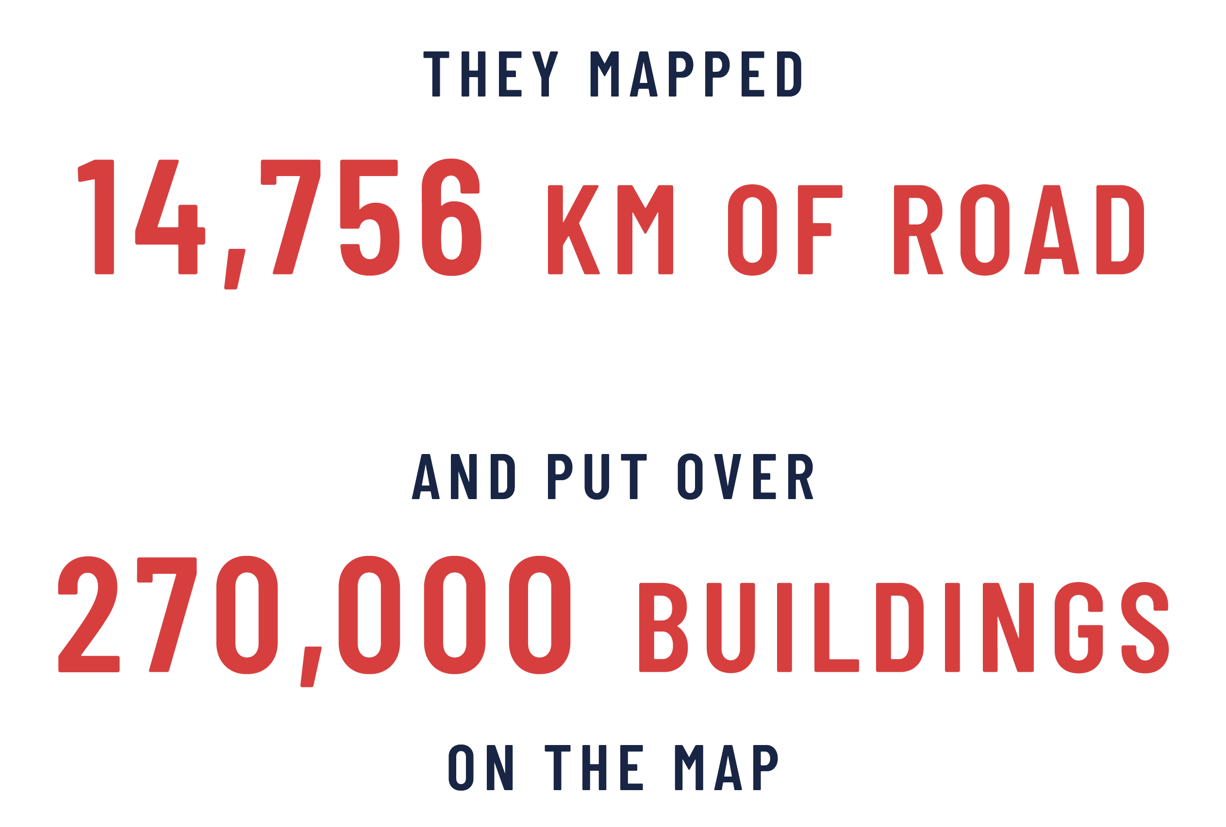
The most affected areas in Uganda were the border districts that only existed as blank spots in OSM. MapUganda, together with Geo YouthMapppers supported the availability of data for the planning and actions of government and field responders, such as the Ugandan Red Cross. MapUganda mapped 27 Ugandan border towns and created 27 digital and paper maps to help local health responders monitor potential avenues for Covid-19 transmission. They mapped more than 250,000 buildings, over 7000km of roads and more than 400km of waterways.

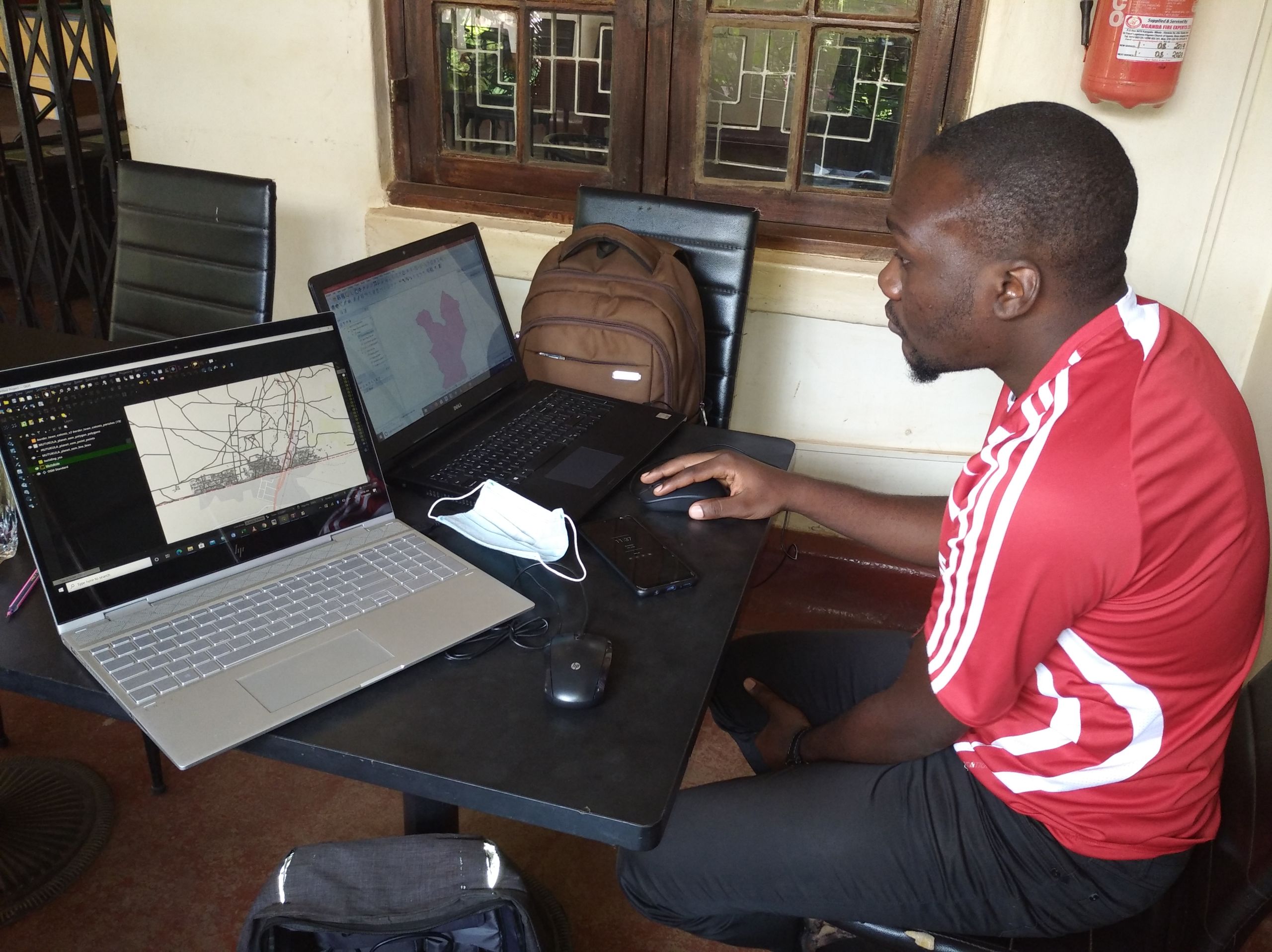
Photo by MapUganda
Photo by MapUganda


They also hosted 36 training events, training 396 individuals in using iD editor, JOSM, Kobo Toolbox, HOT Tasking Manager, QGIS, Validation skills, OSMCha, UMap and healthsites.io.
This was supported by over 26,000 remote mappers who contributed almost 5.4 million map features to #Covid19 Tasking Manager projects, including nearly 4.8 million buildings and over 122,000 km of road, plus extensive health infrastructure data - HOT’s largest response ever in terms of contributions.
M A P P I N G A P A N D E M I C
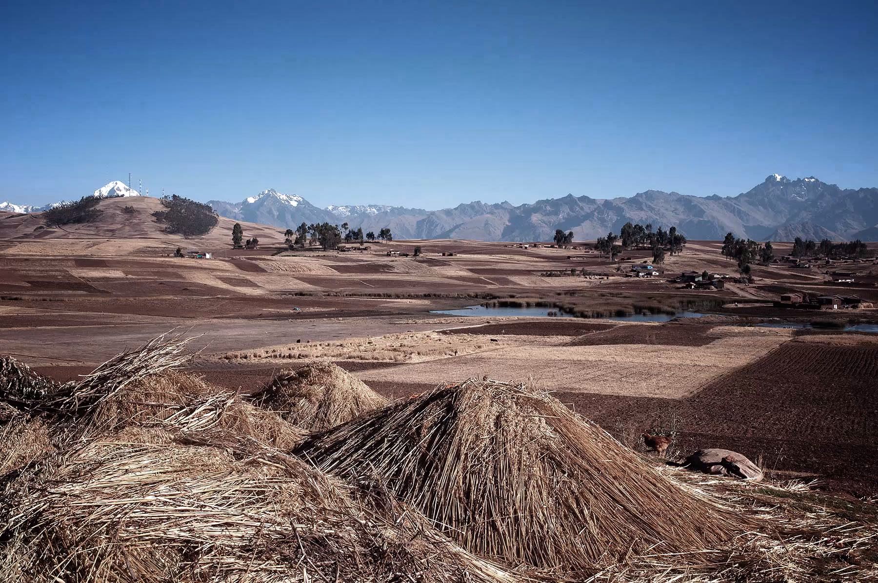
Mapping Health Implications in Peru
The Cusco region of Peru poses particular challenges to public health workers, with a dispersed population of over 1.3 million people living in rural areas ranging from inaccessible jungle to highland areas well over 4,000 meters above sea level.
HOT and GAL Group helped public health officials at all levels of government plan how to locate and support communities by mapping rural and vulnerable populations in the Cusco region of Peru.
These areas could then be prioritized for support through measures like hand washing stations to reduce transmission and baskets of food and basic goods to sustain people through the quarantine. We then used data from the government and global mappers to identify markets and other public areas that could potentially be places of high rates of transmission of Covid-19.

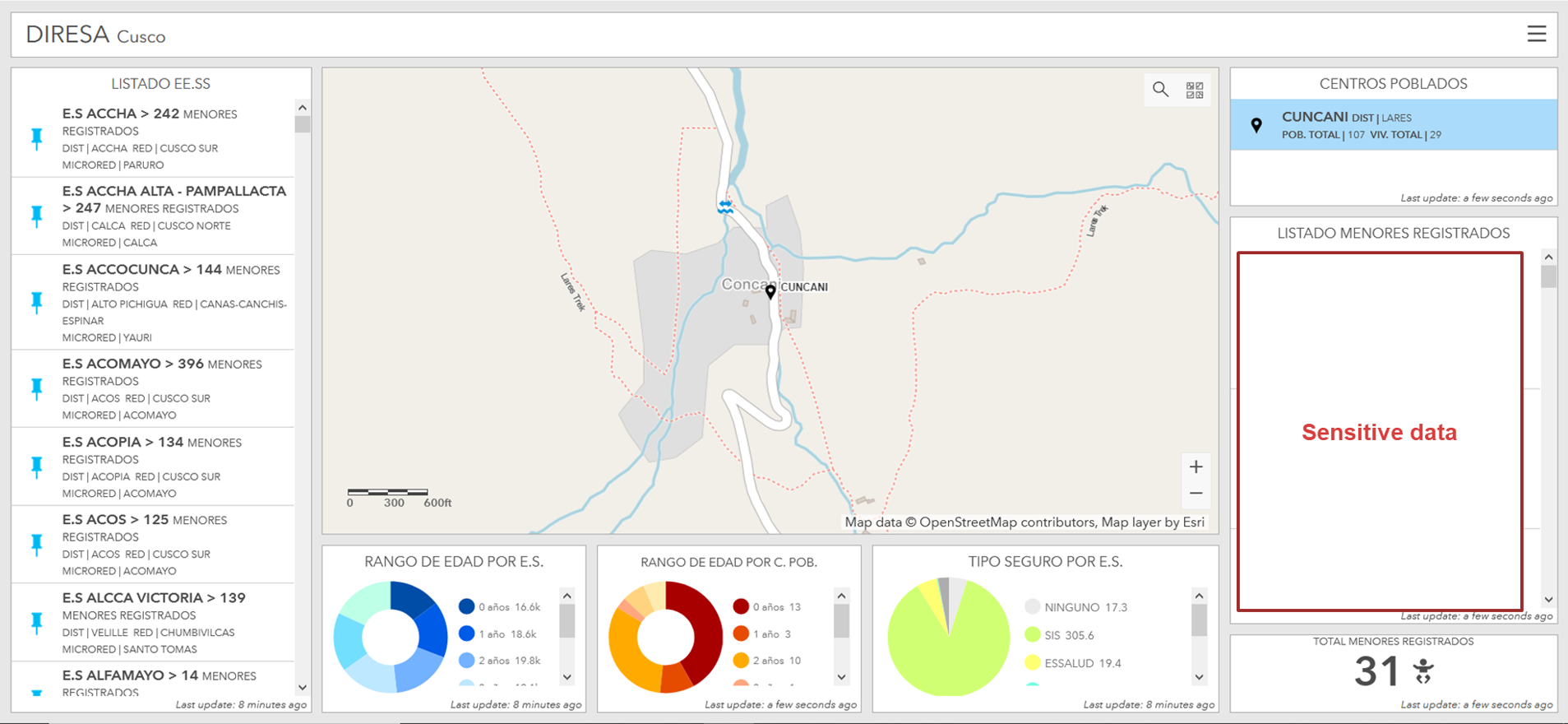
We iterated a geodata dashboard combining government data with the house-level data of OSM to enable the regional Ministry of Health to geo-locate children by population center and local health clinic. With issues such as poor early years development and high levels of chronic malnutrition and anaemia endemic across the region, the authorities have been challenged in understanding the impact of Covid-19 on regular healthcare activities. The real game-changer will be the future functionality to locate children by specific households and to track if they are receiving the correct household visits. The motive behind the platform is that it will help improve long-term management of data with the authorities.
Map data informed critical decisions - from universal cash payments for people in need to maternal and child health. The map data also helped deliver oxygen tanks to 900 patients at home due to hospital overflow. Oxygen was delivered to non-hospitalized patients, who are often safer at home as the hospitals within Cusco were running over capacity.
The company normally in charge of supplying oxygen to the three main hospitals, covering 1.3 million people in the Cusco region, was not able to provide the necessary oxygen. Thanks to a private initiative oxygen was bottled and offered to Covid-19 patients who were prescribed the oxygen free of charge.
"The service is really good. They attend to us immediately. It's not like the private providers who treat us badly and discriminate against us. The most important thing now is that everyone is prepared to confront Covid together."
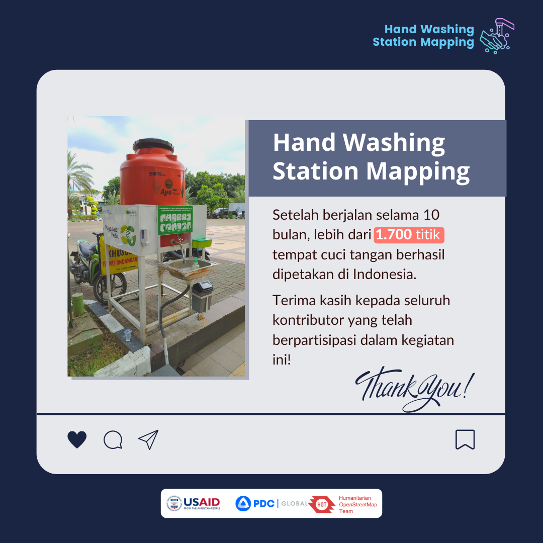
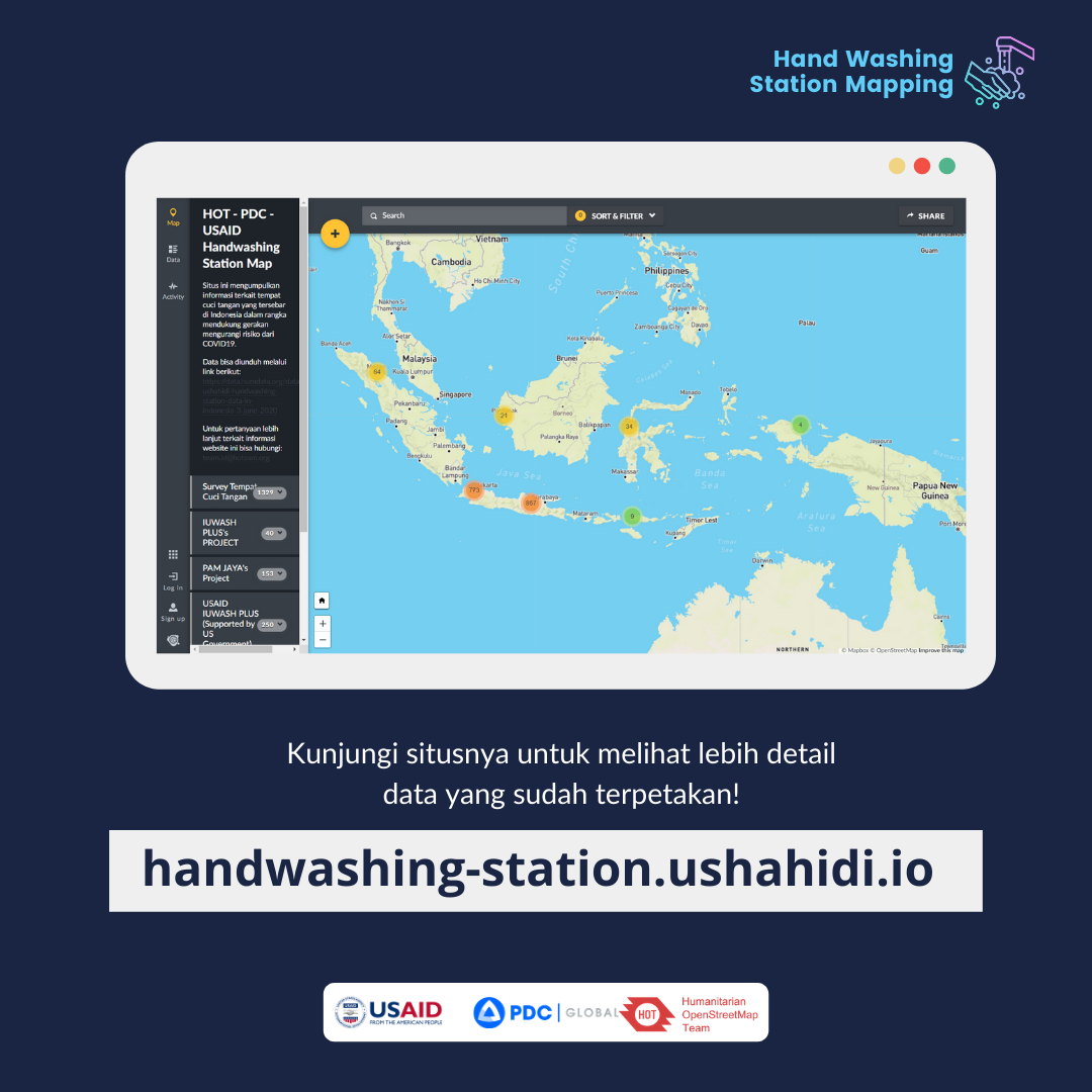
Crowdsourcing Handwashing Station Mapping in Indonesia
Covid-19 made frequent handwashing the new normal for everyone. Therefore, we needed a map where citizens could see the distribution of handwashing stations nearby.
The Ushahidi platform was selected as the tool to collect information using crowdsourcing due to the ease of reporting handwashing stations using only a smartphone or laptop. Social media campaigns were used to create awareness and promote engagement by providing regular statistics on reports received. Short step by step videos encouraged public participation and showed people how to report the handwashing stations around them.
The mapping activity aimed to identify locations and track the distribution of handwashing stations in Jakarta, but succeeded in gathering more than 1,600 handwashing stations across the entire nation. Reports were integrated into the Pacific Disaster Center's InAWARE server which serves as additional information to the government, especially the disaster management agency, to improve knowledge on how people were preventing the spread of the virus in terms of improving their hygiene. Moreover, the data was regularly exported into the Humanitarian Data Exchange (HDX) website to make it accessible for analysis.
USAID, in collaboration with the Pacific Disaster Center and HOT, initiated the mapping of handwashing stations in DKI Jakarta for incorporation into the Indonesian National Board for Disaster Management's (BNPB) national hazard monitoring application, InAWARE, and other mapping applications.
Improving Covid-19 vaccine delivery
The prospect of global Covid-19 vaccine deployment requires an unprecedented logistical operation and prioritization of people in need, both of which depend on a range of geographic data and analysis. While most countries have sufficient national capacity for this undertaking, we anticipate significant gaps in geographic data and planning capacity in areas where state institutions are weak or absent.
Anticipating such needs, agencies specializing in humanitarian mapping and information management have formed a working group to support vaccine delivery. The aim is to provide expertise in a coordinated way and to act as a geographic information focal point for agencies delivering Covid-19 vaccination programs, notably national ministries of health, UNICEF, WHO, and partner organizations.
The C19 VAX Geo-spatial Planning Working Group was created in late 2020 as a continuation of HOT’s Covid-19 response. The Working Group was created to coordinate, collaborate, and anticipate geospatial data gaps or needs in Covid-19 vaccination campaigns. It was also created to coordinate, collaborate, and anticipate gaps and needs in geospatial information management systems.
Strengthening the Covid-19
vaccine rollout
In response to the logistical requirements of a global Covid-19 vaccine deployment, iMMAP, Alcis, CartONG, Humanitarian OpenStreetMap Team, and MapAction formed the Geographic Information Management Initiative for Covid-19 Vaccine Delivery (GIM Initiative).
The GIM Initiative leverages the power of each partners’ expertise to help strengthen the Covid-19 vaccine rollout through geographic data, systems and analysis in 15 low-income countries with acute humanitarian needs, positioning the GIM Initiative as a technical support service to all actors engaged in Covid-19 vaccine delivery.
The GIM Initiative aims to assist partners locally through information management services to tackle critical issues such as the selection of distribution sites when data is not always available, how to plan the journey of health care workers to remote locations when no up-to-date maps exist and no one can estimate accurate transit times, how to ensure the follow-up of vaccinated people when the required database management skills are limited locally, and how to access the most vulnerable communities, some living in undocumented settlements, when information is not available.
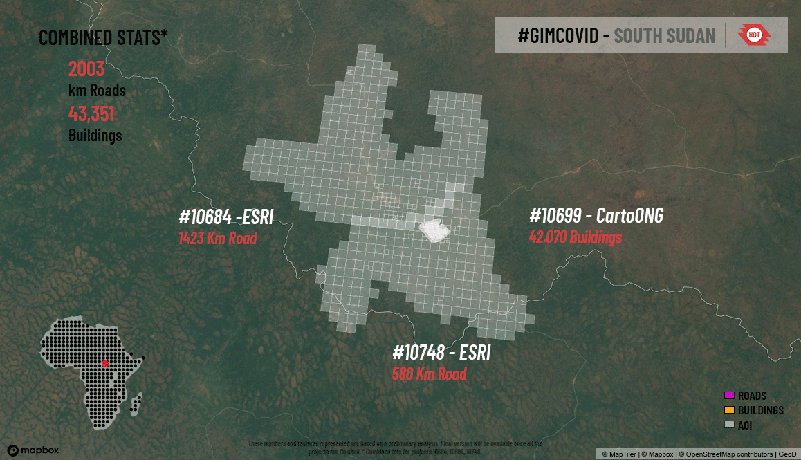
A pilot project in South Sudan allowed HOT to switch gears from the earlier Covid-19 response to vaccination campaigns. It enabled us to understand the information and data gaps and address them with urgency, support geospatial micro planning processes to support the effective vaccination campaigns at the country level, and define and structure detailed geospatial information baseline open data repositories at the country level.
Over 6,000 users have contributed to the pilot project, mapping an area of almost 79,000 km2, including 307,000 buildings and 9,475 km of road.

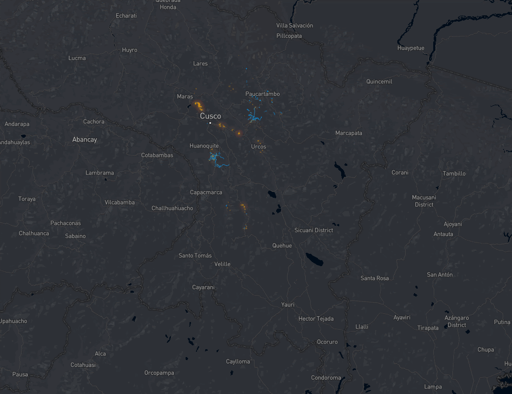
Over 10,000 volunteers came together to map an area home to 1.3 million people in the Cusco region of Peru. Mapping over a 10 week period - blue shows roads, and orange shows buildings. Source: Mapbox
Over 10,000 volunteers came together to map an area home to 1.3 million people in the Cusco region of Peru. Mapping over a 10 week period - blue shows roads, and orange shows buildings. Source: Mapbox

Over 10,000 volunteers came together to map an area home to 1.3 million people in the Cusco region of Peru. Mapping over a 10 week period - blue shows roads, and orange shows buildings. Source: Mapbox
Over 10,000 volunteers came together to map an area home to 1.3 million people in the Cusco region of Peru. Mapping over a 10 week period - blue shows roads, and orange shows buildings. Source: Mapbox

Photo by GAL School, Cusco, Peru
Photo by GAL School, Cusco, Peru
Graphic by Pacific Disaster Center, Adhitya Dido
Graphic by Pacific Disaster Center, Adhitya Dido


Two mapathons, attended by 253 contributors kicked off the mapping in Western Equatoria State, South Sudan.
Two mapathons, attended by 253 contributors kicked off the mapping in Western Equatoria State, South Sudan.
Two mapathons, attended by 253 contributors kicked off the mapping in Western Equatoria State, South Sudan.
Two mapathons, attended by 253 contributors kicked off the mapping in Western Equatoria State, South Sudan.

Two mapathons, attended by 253 contributors kicked off the mapping in Western Equatoria State, South Sudan.
Two mapathons, attended by 253 contributors kicked off the mapping in Western Equatoria State, South Sudan.

Maps and geodata are most useful if they can be used by responders before disaster strikes, such as when planning a response based on a hurricane forecast or in the early stages of an outbreak.

G L O B A L I M P A C T
Mapping to improve disaster preparedness in the Philippines
PhilAWARE is a custom hazard monitoring and early warning system to improve disaster management and decision making in the Philippines for use by the Philippines’ National Disaster Risk Reduction and Management Council (NDRRMC) of the Office of Civil Defense (OCD). This will also ease the sharing of information among the country’s disaster managers from the national, regional, and local levels, with warnings and alerts disseminated to the impacted communities.
Tasked with filling OSM data and knowledge gaps gaps in the critical geospatial data needed for DRRM, HOT Philippines and OSM communities in the Philippines focused on remote mapping, OSM training, and field mapping, including neighborhood boundary information, and transportation and critical lifeline assets such as hospitals, schools, police, and fire stations. Field work was carried out in the province of Pampanga..
Field Mapping and Training
- 18 municipalities trained: Arayat, Guagua, Macabebe, Mexico, San Luis, Santa Rita, Bacolor, Lubao, Magalang, Minalin, San Simon, Santo Tomas, Candaba, Mabalacat, Masantol, Porac, Santa Ana, Sasmuan
- 13 municipalities mapped: Arayat, Guagua, Mexico, San Luis, Santa Rita, Bacolor, Lubao, Minalin, Santo Tomas)4 cities/municipalities unable to commit due to the Covid-19 situation: Angeles, Apalit, Floridablanca, San Fernando
The PhilAWARE project established standards for data quality and created an avenue for community ownership of data by using a participatory mapping model, and created a resource for future data uses: the OSM basemap can now support the SDGs.
The PhilAWARE project was a collaboration with USAID and the Pacific Disaster Center (PDC).
Photos by HOT Philippines
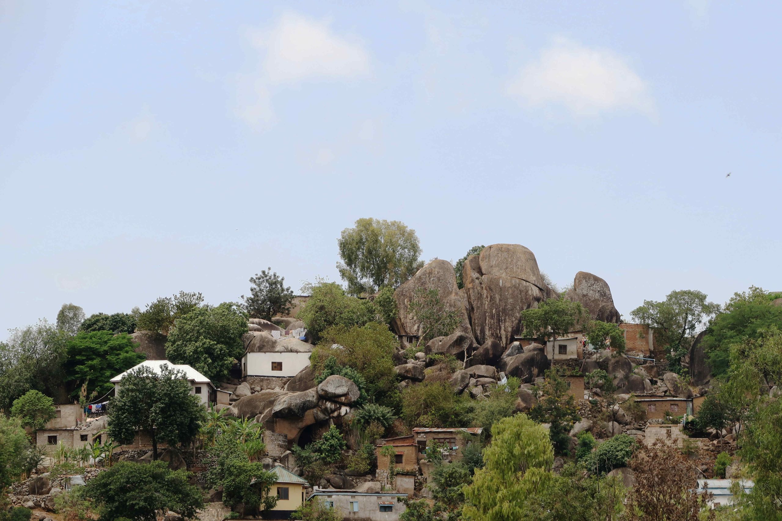
Mapping communities vulnerable to rockslides in Mwanza, Tanzania
The risk of rockslides in Mwanza is relatively high due to earthquakes and erosion in the area. The team learned that when rockslides do occur, they mostly occur in Nyamagana municipality. Based on interviews with government representatives, the team designed the data acquisition method that captures both historical rockslides as well as areas at risk.
To carry out the fieldwork, the teams were organized into groups of two students and one community leader (or Balozi). Community walks were carried out in the area of interest during which both historical rockfalls and areas prone to rock falls were recorded using mobile phones.
Historical rock falls were recorded at a household level, meaning, households directly affected were mapped and their residents interviewed. On the other hand, the areas prone to rock falls were traversed and encircled on foot, capturing the entire area at risk.
The team utilized a mixed-method data collection approach, which ensured a more comprehensive map of over 800 locations of rockfall risk. The team worked with students in the field to map historic and at-risk rockfall locations, reviewed aerial imagery, and gathered risk locations in community and stakeholder meetings using mobile phones.
The students are equipped to use their new skills in future risk mapping research and government officials also improved their understanding on how GIS can be used in disaster preparedness.
Photos by Primoz Kovacic - Spatial Collective
Building resilience through disaster exposure data
The METEOR project was a three-year initiative to generate disaster exposure data and models in two pilot countries — Tanzania and Nepal. The process has since been repeated in another 45 official development assistance countries. All of this data is openly accessible and also in the form of interactive online maps.
Having disaster exposure models at the country level is an asset for building disaster resilience in countries through enabling measures to minimize risks and mitigation plans.
HOT and our local partner OpenMap Development Tanzania (OMDTZ) facilitated a workshop with all of the major stakeholders in disaster management in the country, training them on exposure, flooding, earthquakes, and volcanoes.
The METEOR Project was supported by the UK Space Agency International Partnership Programme.
© 2021 GEM Foundation and the METEOR Project Consortium.


G L O B A L I M P A C T
P A R T N E R S H I P S
Mapping an area home to one billion people takes a global movement of thousands of organizations and communities partnering for impact. HOT brings together humanitarian organizations and government agencies who require data to inform life-saving decisions, with citizens and communities that create and advocate for open data. We work with a wide range of organizations, from local community groups to global NGOs, from private sector organizations to YouthMappers chapters at universities.
We thank the hundreds of organizations that worked with HOT this year to help make our vision a reality.
G L O B A L I M P A C T
P A R T N E R S H I P S
Mobilizing remote mappers for Covid-19 and hurricane preparedness in the Caribbean
The Caribbean region is highly exposed to many hazards including hydro-meteorological, seismic, geological, biological and man-made. HOT supported Caribbean Disaster Emergency Management Agency (CDEMA) Covid-19 and hurricane preparedness campaign by leveraging virtual volunteers from 13 corporate partnerships and connecting with volunteers around the world. This brought non-conventional users into OSM and also helped HOT to share and socialize the democratization of open mapping tools. The objective was to map the entire Caribbean in a short timeframe in preparation for hurricane season and in response to the pandemic. Two countries, Jamaica & Anguilla, were fully remote mapped and validated.
Partnership for anticipatory action
HOT became a partner of the Anticipation Hub in order to position OpenStreetMap as a key element for anticipatory humanitarian action and increase map data use for climate action with many organizations.
The completeness and maintenance of local map data is a key element in anticipatory action, as it can support local actors in their decision-making. HOT can help to expand the application of OSM for anticipatory action by supporting NGOs, governments and other actors in the Anticipation Hub to identify data gaps, and to create and effectively use OSM data in their work. This involves connecting organizations with existing OSM communities who are leading on mapping where they live.
My School Today!
Partnering to map the world's schools
In coordination with the Sustainable Development Solutions Network (SDSN), HOT supported the launch of an initiative to support students and local communities in putting their school on the map.
“This idea of mapping schools globally brings in another crucial element, and that is crowdsourcing of knowledge and engagement in the SDGs. Because with the tools that SDGs Today is bringing to this project, everybody can participate in describing where your schools are, in geographically tagging them."
- Jeffrey Sachs
President of SDSN
My School Today! Launch Event
Video courtesy of UN Sustainable Development Solutions Network (SDSN) - My School Today! Launch event
Impacting one million lives
Membership in the Million Lives Club, an initiative of the Global Innovation Exchange, helps us connect innovators, development funders, and mapping communities together to support the creation of data that puts communities on the map, helping to ensure that they receive the resources and consideration they deserve. This achievement is a testament to the contributions of OSM communities around the world in creating maps and geographic data that are invaluable for responding to disasters and planning for community development.
The Million Lives Club celebrates innovators and social entrepreneurs who are reaching new horizons of impact and improving the lives of those living on less than $5 a day.
G L O B A L I M P A C T
T E C H N O L O G Y & I N N O V A T I O N
Evolving AI to amplify efforts
Integration of RapID & NESTA funded AI-assisted mapping experiment
The exploration of AI-assisted mapping allowed HOT to cut through the hype and hyperbole to empirically explore the most effective ways that machine learning and artificial intelligence (ML/AI) can be introduced into the OSM ecosystem in a responsible and ethical way. Through the NESTA experiment we were able to test the speed and efficiency of advanced and beginner mappers. The results of this experiment guided us toward understanding how different users benefit from AI assistance and where AI can be used to enhance the skill set they have. By finding how to integrate AI in this way, we have the opportunity to dramatically amplify the efforts of both mappers and validators to make more quality data available for humanitarian and development needs.
Achieving this objective means we can now leverage the potential these advanced data techniques bring to the open mapping space.
Deep dive design research to understand core user needs and problems
Over the past year we have worked hard to enhance our technical solutions by seeking to understand how our products could better serve the needs of our users and build an experience that increases use and access. To respond to this HOT's tech team conducted a range of design research activities to achieve this end.
A deep dive into ‘who we serve’ was conducted to capture the wide and diverse user groups we currently serve. Building on this foundation, the team then undertook two Rapid Assessment and Design Sprints to better understand specific problems such as how people map bigger and better as groups and how we connect with local needs to motivate the contribution of local data. Finally we shared a list of priority problems and personas that we feel represent the views and voice of our communities that we plan to tackle in depth through our improved collective-centred approach to tech development.
The year was a year of learning with our communities to improve not only what the HOT tech team builds but how we build it. We want our future to focus less on building our tech for our communities and more on building tech with them.
Engaging users in tech design
HOT’s technology strategy sets out a basemap from which our technology can be cultivated, grow and thrive. Creating the ‘t21 basemap’ - our foundational guiding ethics, principles and direction from which our tech is built upon - has allowed us to engage widely with our stakeholders and ensure we understand what people value, what they feel is important to them and then outline the foundations from which our future can be launched.
HOT’s product suite is a demonstration of stakeholders (typically resource holders) determining our direction. With the t21, people will know what we stand for and what we stand against and will clearly understand what they can do to contribute to our common goals.
New version of Tasking Manager
Developing the latest version of Tasking Manager has involved stabilizing core infrastructure, integration of agile process, fortnightly release schedule and user engagement sessions. The result has been the most user supported and valued Tasking Manager in the history of HOT enabling more effective and impactful organized mapping efforts.
Recognizing the value that organized mapping has given to individuals at both the local and remote levels, the Tasking Manager has continued to connect mappers despite physical distance. Over the past year, we have made 37 releases and crossed a few exciting milestones.

Working with our community of mappers and validators, we delivered a new version every two weeks.

In the OpenStreetMap ecosystem, HOT strives to be a catalyst, enabler and amplifier. Developing tools, sharing knowledge, building networks and partnerships, offering training, coordination and funding to OSM communities is how HOT works to elevate their work producing maps and data that are meaningful to them and their communities.
E L E V A T I O N
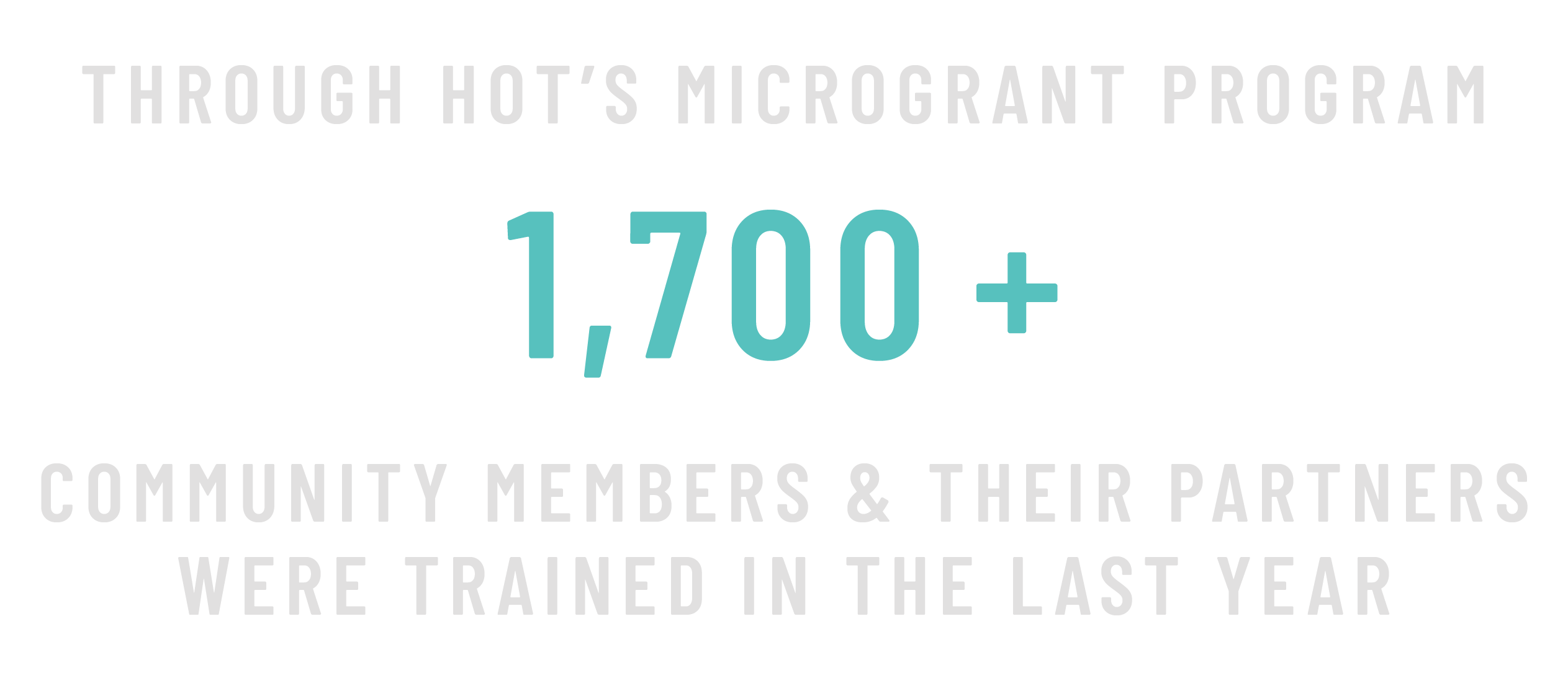
Microgrants
HOT developed the Microgrants Program to help open mapping and open data communities around the world with the resources they need to grow their activities and impact. Microgrants elevate local expertise by helping OSM communities develop leadership skills and broaden the ways in which open mapping and data is contributing to achieving the Sustainable Development Goals.
E L E V A T I O N

They hosted 93 training events, training 693 individuals, including 411 women, in using iD editor, JOSM, Kobo Toolbox, HOT Tasking Manager, QGIS, Validation skills, OSMCha, UMap, Transifex, and more.
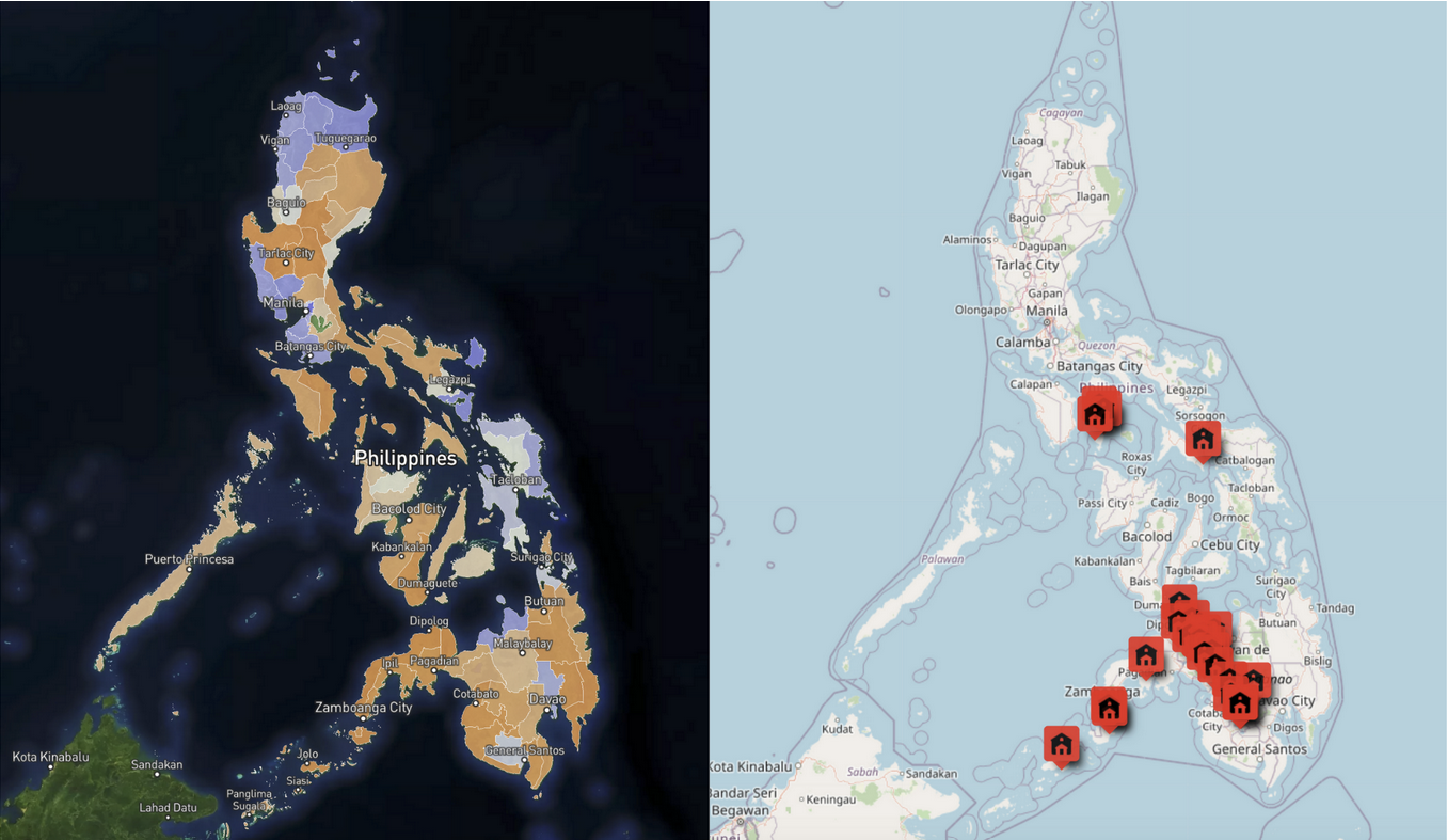
Since 2017, 66 communities and individuals have received a HOT Microgrant.
*HOT supports mapping in a range of contexts globally. The name and results of one Microgrant recipient will not be published, to protect their security, due to the context they operate in.
Yer Çizenler
Facebook Community Impact Microgrant
Yer Çizenler’s project added Turkish language support to OpenStreetMap related tools, translated existing OpenStreetMap documents into Turkish and expanded the infrastructure of its volunteer base while considering gender equality and community diversity.

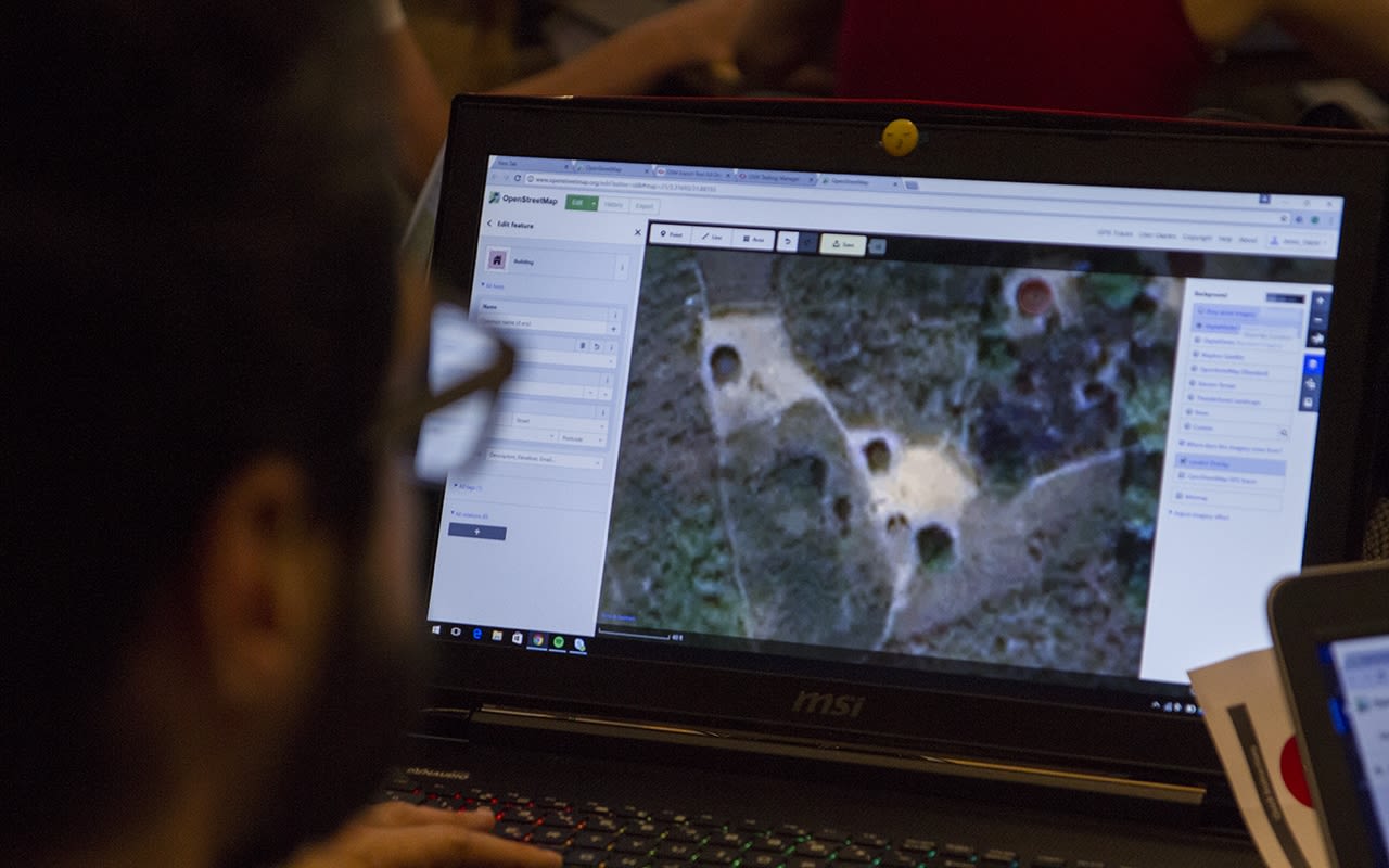
Photo by Yer Çizenler
Photo by Yer Çizenler
They organized seven online workshops and the number of members of the Turkish translation team reached 44 on Transifex.
Practical Action Bolivia
HOT Microgrant

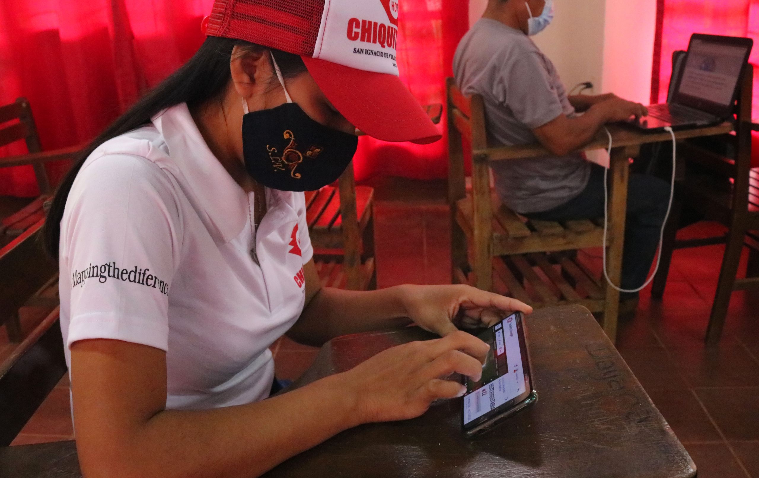
Photo by Practical Action, Bolivia
Photo by Practical Action, Bolivia
Practical Action Bolivia established the HOT Chiquitania mapping community as part of their microgrant project to map areas of Bolivia struck by last year’s devastating forest fires in the Amazon. In Bolivia alone, the fires destroyed more than three million hectares, causing widespread damage to the biodiversity, killing animals, and harming livelihoods.
Practical Action Bolivia hosted eight trainings to support the affected communities, training 52 people, 22 of whom were women, and created a site with training resources in Spanish. With the mapping skills they gained, the community mapped over 10,000 buildings and 10,000 kilometers of road in the affected areas.

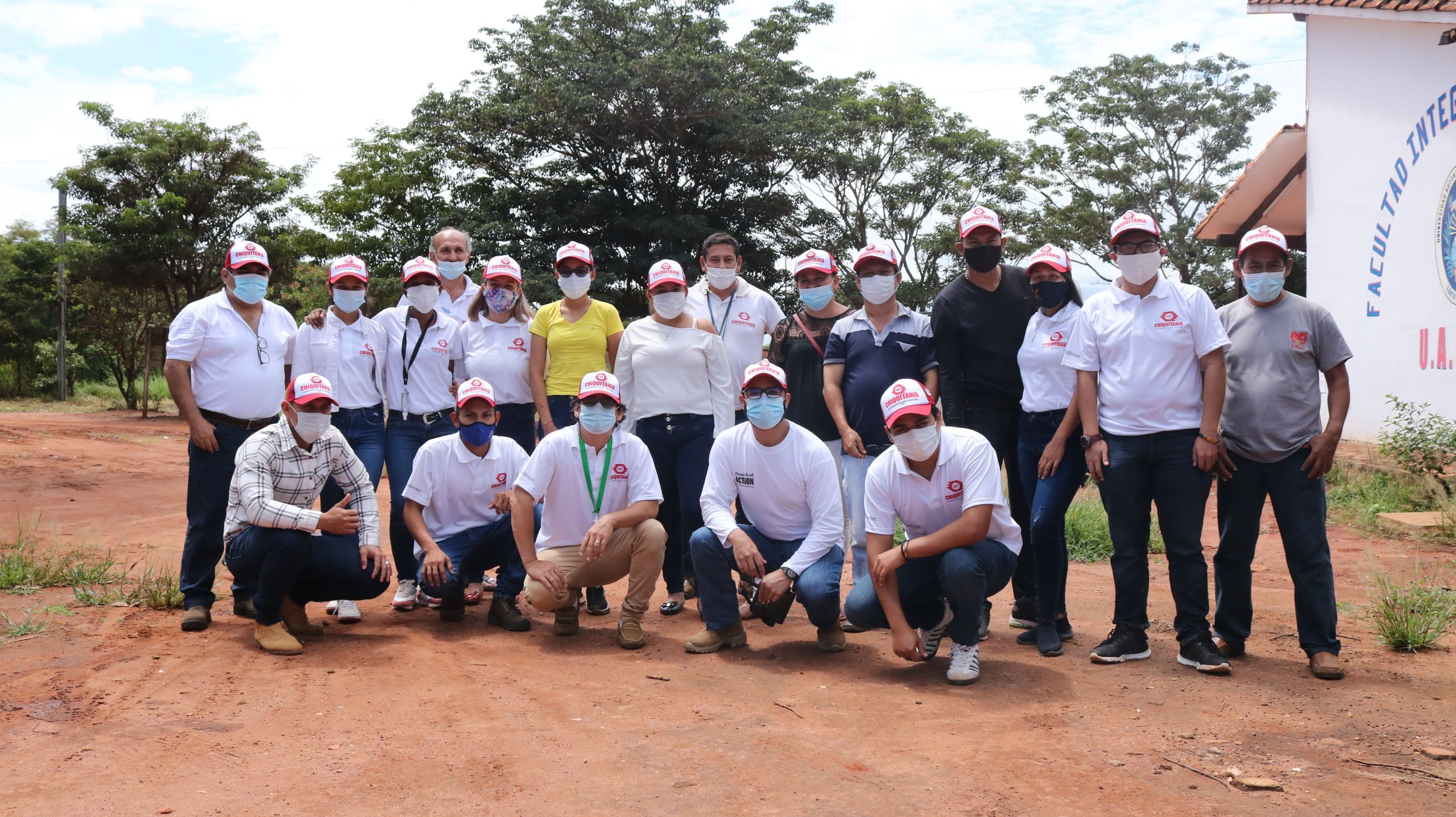
Photo by Practical Action, Bolivia
Photo by Practical Action, Bolivia
OSM Kenya &
YouthMappers Kenya
Facebook Community Impact Microgrant
The main aim of the project was to improve the diversity of the OpenStreetMap community in Kenya by increasing female membership. A second objective was to map female health services. The project was supported by Map Kibera.
OSM Kenya and YouthMappers Kenya mapped 324 health facilities in Nairobi and the surrounding counties, 6,920 buildings, and trained 37 mappers (28 beginners and nine intermediate mappers, 35 of whom were female).
The project helped to grow community membership with twenty-eight new members and improved its diversity.
MapBeks
Facebook Community Impact Microgrant
The MapBeks mapping community launched its UNMAPPED PH (Unmapped Philippines) campaign in September 2020. The project aims to map the most remote and unmapped towns in the country on OpenStreetMap through training and encouraging LGBT advocates and allies.

Map by MapBeks
Map by MapBeks
The selection of the towns was based on a study by Thinking Machines PH last June 2020. The study showed the level of OSM building footprint completion at the community, town, and provincial level in the Philippines. The results also identified 24 towns that did not have a single building footprint on OSM. These areas are home to more than 500,00 individuals or 100,000 families, and are located in the most remote areas in the country.
Mental Health aWHEREness
HOT Microgrant
Mental Health aWHEREness used their microgrant to map more areas, train more people how to map, and build an evidence-base to show government and policymakers where there is a lack of mental health resources available for those in need in the Philippines.
Mental Health aWHEREness created an online platform and crowdsourced map that shows the locations and information on mental health services to make it easier for people to look for professional help. With a map, more people dealing with mental health issues can find the information they need safely, securely, and without judgement. Mental Health aWHEREness not only mobilizes volunteers to map where and what services are available and trains people how to map, but it also provides a non-judgemental space for people to talk about mental health.
Video by Mental Health AWHEREness
OSM Sierra Leone
HOT Microgrant
In a country that suffers from floods and even epidemics – the Ebola outbreak in 2014 devastated the country – contributing to the map means communities can access the humanitarian and development assistance they need to thrive.
OSM Sierra Leone has worked to create university mapping chapters, partner with the Red Cross and other organizations, to increase the quality of maps across the country. The HOT Microgrant served as a catalyst to strengthen and expand their community of mappers and provide relief and development organizations with the information they need by training more individuals and increasing the diversity of their community, particularly female mappers.

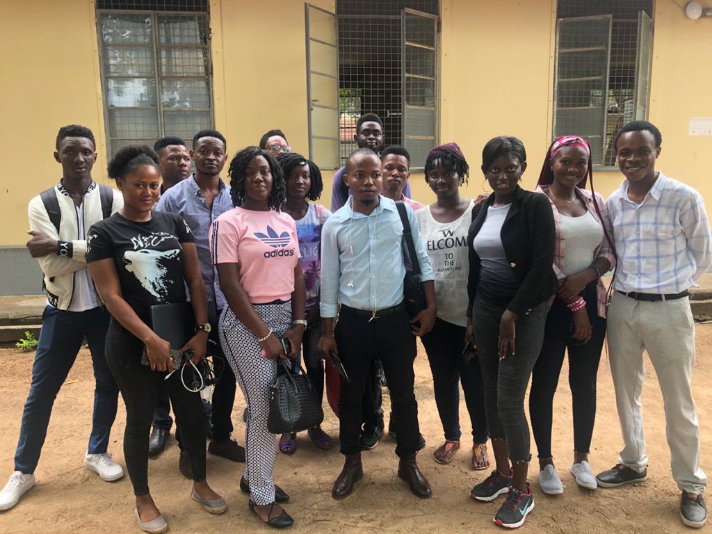
Photo by OSM Sierra Leone
Photo by OSM Sierra Leone
OSM Sierra Leone trained 48 people, 41 of whom were new to mapping. They engaged students of the University of Makeni and Canadian college and established Youth Mappers Chapters there.
The project resulted in 70,887 map edits, 69,988 buildings mapped, and 68 health facilities mapped and uploaded to the healthsites.io platform.
OSM Zambia
Facebook Community Impact Microgrant
OSM Zambia used their Facebook Community Impact Microgrant to map waste collection zones in the rapidly growing city of Lusaka to support waste collection and disposal.
The lack of maps for solid waste collection zones contributes to indiscriminate disposal of solid waste in the community because there was little to no knowledge of the authorized solid waste collection companies working in the areas.

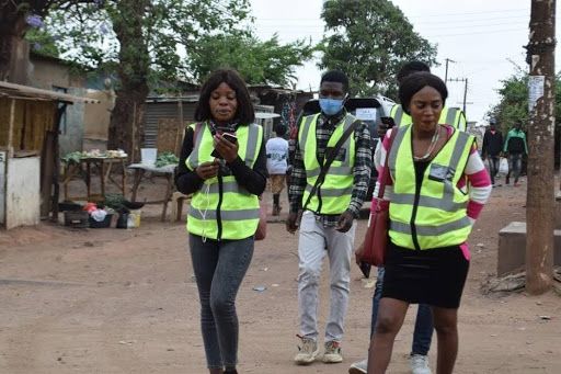
Photo by OSM Zambia
Photo by OSM Zambia
During the data collection exercise by students from the YouthMappers UNZA chapter, they were able to map boundaries for the solid waste zones in six of the peri-urban areas. They also identified the major road networks in these peri-urban areas where there are dumpsites in order to know what modes of transport can be used and route the vehicles that collect solid waste.
Resilience Mappers
Facebook Community Impact Microgrant
With support from a Community Impact Microgrant, Resilience Mappers has built a web dashboard for geospatial data to support efforts by the Ugandan government to help residents of low-income communities who have been most affected by Covid-19 lockdowns.
Video by Resilience Mappers, Uganda
They trained seven mapping communities on how to contribute to OSM for informal settlements.
Since there was no single inventory that could be accessed by members in the community and aid agencies in these settlements, they created a web map repository for Kampala’s informal settlements, which offer several benefits over paper maps, such as being quick and efficient to monitor, easy to update, allowing quick retrieval and queries, and offering faster integration of complex, multiple spatial, and non-spatial datasets.
E L E V A T I O N
In addition to the Microgrants Program, HOT elevates communities through training, internships, mentoring and an annual summit that connects communities, showcases OSM community impact and provides a space for discussion and debate.
Training

Of these, 98% were trained by Microgrant recipients rather than by HOT staff, demonstrating the lead local partners have taken in OSM data capacity building.
Advanced mapping and validation training for corporate partners started in 2020, training to map roads, rivers and land use.
We now provide a more engaging experience for volunteers and a way to develop advanced mapping skills, strengthening technical capacity for activations and more complex projects. Two-hundred and eighty-five mappers were trained from 5 corporate partners (Accenture, Experian, Marsh McLennan, ARM & Salesforce), providing a clear way to evolve into a longer-term engagement with volunteers.
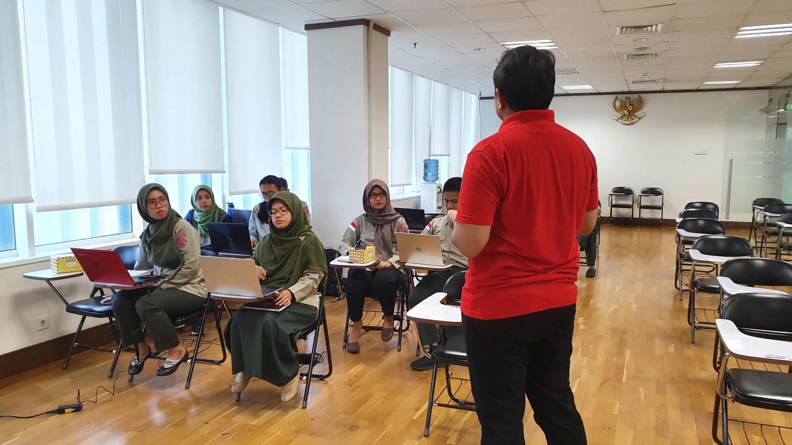
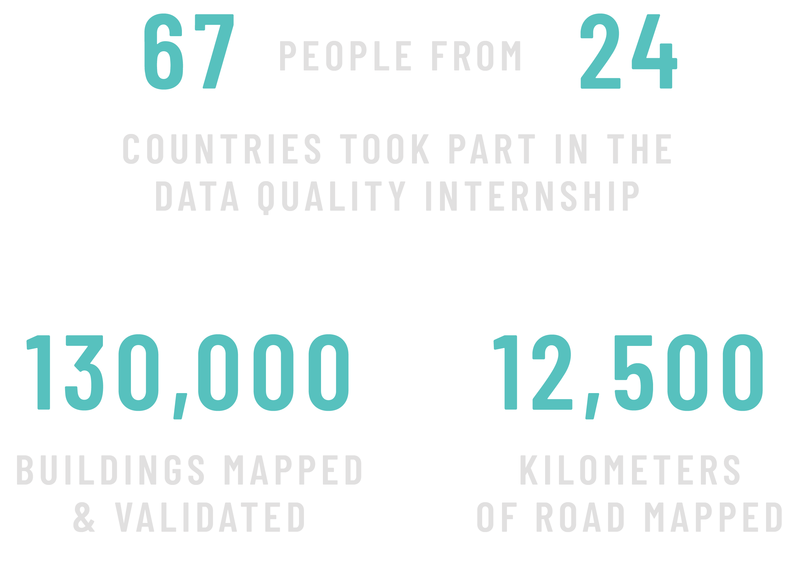
Data Quality Internship
The HOT Data Quality Internship Program is an intensive training and professional development opportunity to develop advanced skills in a wide range of geospatial tools. The aim of the program is for interns to become experienced members of the validation community, ensuring that data going into OpenStreetMap is correct and complete.


"It is crucial to ensure that geospatial data is coherent with the ground truth. Only in this way can data be an accurate and truthful resource for detecting changes in time and space and for emergency coordination. I think that a validating system driven by the community itself is the most constructive way to get even more involved, personally guiding contributors with less experience so they can improve their abilities."
From August - October 2020

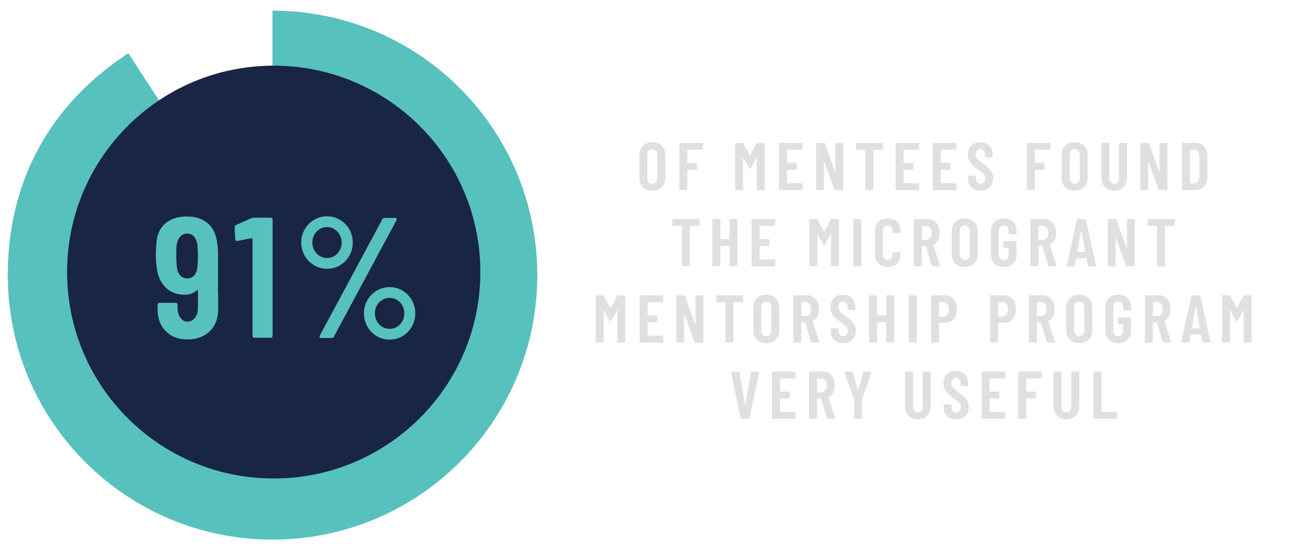
Mentoring
As part of the Facebook Community Impact Microgrant applications, HOT tried a new mentorship approach to OSM community members through the application process. Between 1 January and 31 January 2021, communities who signed up to the program were paired with mentors who would help with project identification and development and guidance on budget creation and project plan articulation. OSM communities and mentors were paired based on skills, experience, location, expertise, and interests.
By providing guidance during the ‘idea development’ phase, the mentorship program’s goal was to enable communities to submit more developed proposals with clearly defined project objectives and detailed, realistic work plans and budgets.

“The mentorship pushed us to critically think about the problem that we’re trying to solve and how best to curate a convincing proposal. The feedback was very constructive, and this really helped and motivated us to finish the application."
E L E V A T I O N

HOT SUMMIT 2020
"You are collecting data with communities, and together you are using it to force policy makers to listen to them. In the end, data is power because it's a way for people to speak directly to power, through being included in their data. You're at the forefront of making this happen, and you're going to bring the power of one billion people's voices into the data over the next five years. The work of the OpenStreetMap community shows every day, that data is a power that can, if we will it, be collectively analyzed and used for good, to protect the vulnerable, and to reduce injustice"
- Dr Claire Melamed, CEO at Global Partnership for Sustainable Development Data
The 2020 HOT Summit was the first virtual Summit we attempted and resulted in the highest turnout yet, with over 800 registrants. This was also the first Summit to be totally free for all participants and held "closer to home" for all participants as it was staggered across three time zones: Asia, Africa/Europe and the Americas, to maximize participation across the globe.
The virtual Summit was remarkable for a number of reasons, but perhaps the most significant was the level of inclusion it achieved, unrestricted by visas and travel costs, the virtual setting allowed for the widest possible group of those invested in humanitarian open mapping. In 2020, we were also able to offer the first HOT Summit Community Microgrant, supported by Esri.

HOT’s global positioning centers around equality, inclusion and local leadership. This involves both how we support, interact with and promote members of the OSM ecosystem and our partners, and also how we build a diverse and inclusive global team that reflects these values.
G L O B A L P O S I T I O N I N G
Regional Open Mapping Hubs
We are setting up four regional Open Mapping Hubs, with the mandate to support and scale OpenStreetMap communities around the world.
The Open Mapping Hubs mark the culmination of a decade of HOT’s work and commitment towards building open source tools and investing in open data interventions led by local people and through local knowledge.
The purpose of the Hubs is to inspire and mobilize an OpenStreetMap movement across each region, while decentralizing decision making and resource allocation closer to the communities and partners they serve in priority countries.
Launching the first two regional Hubs greatly expanded the scope of HOT's work and significantly increased its capacity within those regions. Additionally, support can be more localized and tailored to communities with regional staff who have the unique and necessary perspectives to speak and work with communities. This also makes HOT more reflective/representative of communities themselves and increases efficiency.
These Hubs are the necessary precursor to much of the work envisioned over HOT's next four years and the primary structures through which HOT will work. This shift will make HOT more locally-responsive, locally-led and overall, reinforce the global network.
Open Mapping Hub - Asia Pacific
There are several open mapping communities already doing amazing work across Asia-Pacific. Their work needs to be identified, recognized, supported and amplified. Our goal is to work with these communities in 25 priority countries to expand and deepen the open mapping work in Asia-Pacific to generate meaningful data and promote its effective use. Every piece of data we produce together with local communities will be open and publicly accessible to everyone for free.
Dr. Nama Budhathoki is the inaugural Regional Director of the first regional Open Mapping Hub in Asia-Pacific. Nama wrote his doctoral dissertation on OSM; he successfully led the World Bank’s OSM-focused Open Cities Project in Nepal, and he founded and developed Kathmandu Living Labs (KLL). Nama is an international leader and is well known in OSM communities. Nama has also served on HOT’s Board of Directors, making him uniquely qualified for this regional role.

“Our vision is to create a sustainable OSM ecosystem in Asia-Pacific. In 5-10 years time, we aspire to see government, humanitarian and development agencies commonly using OSM data in their planning and decision-making. We are also committed to promoting the active participation of underrepresented groups and individuals in the OSM movement. Equally importantly, we envision developing OSM into the most popular map service in entrepreneurial activities, economic development and citizens’ everyday lives.”
Open Mapping Hub - East and Southern Africa
The Eastern & Southern Africa Open Mapping Hub is an ecosystem of individuals and organizations dedicated to increasing the use of OpenStreetMap tools, while ensuring high quality, locally validated data is generated to power and influence local and regional interventions. The Hub facilitates local mapping activities, knowledge sharing and learning, distributes funding and provides technical training to nurture, support, and amplify open mapping in 22 countries in the region.
Monica Nthiga is the Regional Director of the Open Mapping Hub in East and Southern Africa. Monica brings a unique blend of experience from working in open data and open source communities and organizations in East Africa. Monica joins us from a long-term partner of HOT, Ushahidi, where she served as Director of Implementation.

“Disaster preparedness and response capacity in the region continues to be stretched by changing climatic conditions, poverty, limited internet connectivity and mobile technology to adapt or be adequately prepared for disasters. The region is also characterised by a strong youth workforce, formal and informal self-organized community groups that continue to struggle to access financial and technological resources to coordinate and respond to these disasters at a local level. I envision building diverse and long term partnerships whose primary goal will be to mobilize and lobby for technical and financial resources directed towards OSM communities and citizens to sustain initiatives that tackle preparedness for more inclusive response.”
G L O B A L P O S I T I O N I N G
Gender, Diversity & Inclusion
At HOT we strive to create a diverse and inclusive environment that reflects our global community.
One way we are doing this is through expanding our leadership team, in order to better integrate different perspectives and experiences, and contribute to an open and innovative environment. Over the past year we have added two new Directors who lead our regional expansion in Asia Pacific, and Eastern and Southern Africa. Over the next year, we will add two more directors, leading our work in West Africa, and Latin America and the Caribbean.
Over 50% of HOT's staff members identify as women. We are using new recruitment processes and outreach methods and building a robust framework to overcome the legal and financial barriers to employing a global team. Additionally, we have committed to Diversity, Equity and Inclusion training for our leadership team, which will take place before the end of 2021.
In our work with partners and communities, we strive to ensure that everyone is welcome and respected. This can mean challenging the status quo and facilitating open dialogue.
Inspired by ‘A Call to Take Action and Confront Systemic Offensive Behaviour in the OSM Community’, the Humanitarian Open Mapping Community Working Group (CWG) organized the webinar #ChooseToChallenge: Sexism and Misogyny in the Open Mapping Ecosystem because when women don’t feel safe, invited or welcomed, this affects the use and usefulness of data and perpetuates gender inequality. Without the contribution of women, maps are incomplete.
Sexism and Misogyny in the Open Mapping Ecosystem webinar, Session 1
“Sexism is not just a question in open data communities, it affects all dimensions of society (policies, knowledge, etc). We need to improve diversity in the creation of data. When we don’t allow women to feel safe, invited or welcomed, then we don’t allow this sector (open mapping) to have a diverse vision, and so we don’t have data that reflects the community. We affect data and the place of women in society, its uses and generation so we maintain a non-diverse society.”
A second session was held in a later time zone.
The webinars were attended by 147 participants and viewed more than 600 times on YouTube.
OSM training program for women and girls
OSM Kenya, a 2020 HOT / Facebook Community Impact Microgrant recipient, ran a virtual three-month training program for women and girls interested in OSM. Activities included carrying out a community survey, identifying gaps and challenges, and figuring out what was needed next. The key focus was on community growth, especially in terms of diversity and membership. While some virtual activities introduced new mappers to the community, improving diversity was a challenge. In response, OSM Kenya designed a women-only training program that ran for eight weeks and were able to train a group of 35 beginner-level and intermediate-level mappers on all aspects of open mapping. Activities included hands-on workshops, presentations, and mapathons. During this period, they had some successes, learned a lot, but also had a good share of challenges.
International Women’s Day
In recognition of International Women’s Day, two of HOT’s corporate partners, Accenture and JPMorgan Chase, contributed to gender-focused projects on the Tasking Manager. During the month of March, 540 Accenture volunteer mappers added 38,265 buildings and 4,478 km of roads. JPMorgan Chase ran five mapping events throughout the month dedicated to International Women’s Day.
Colonialism in open data and mapping
Maps and digital data have played crucial roles in humanitarian aid. While it can benefit local communities to add data and features to the map, humanitarian actors and mappers should take note that we are not only mapping houses, roads, and infrastructure, but also mapping the land, the oceans, and the communities who live in and are stewards of that space.
To highlight this ethical challenge, we created a platform to discuss the decolonization of open data and mapping and the effect of representation and power in humanitarian mapping.
Colonialism in open data and mapping webinar - Session 1, Asia Pacific time zone
A second session was held in the Europe-Africa time zone. Together they have been viewed over 900 times on YouTube.
“People need to be aware of what happened in the past regarding colonialism and colonialism in data – we have data policies that are there for the interest of other people. But the local people and communities are left out. If we make it open, local communities can better protect themselves.”
The webinars were viewed more than 900 times on YouTube.
Photo by HOT Indonesia


The past 12 months represented a period of unprecedented growth at HOT. We've built a great foundation, a great team and deep knowledge. Looking towards the horizon, it’s time to take bold action using what we've learned to provide real, tangible, and exceptional value to community organizations and partners.
H O R I Z O N
Y E A R O F A C T I O N
Launching new Open Mapping Hubs
We are planning the opening of two more Open Mapping Hubs in West and Northern Africa (Dakar) in late 2021 and Latin America and the Caribbean in 2022 (location TBC). We're already in the process of getting the West and Northern Africa Hub operational, having hired a Regional Director and exploring the legal framework for registration. In Latin America and the Caribbean, after initial conversations with members of the community, we are adjusting to a more participatory and inclusive approach and look forward to innovative models and roles in the regional Open Mapping Hub as it comes 'online.'
Expanding 'Open Cities' into
Latin America and the Caribbean
Following on the Open Cities Africa experience in Ghana and Liberia, we are implementing the Open Cities Latin America and the Caribbean project in collaboration with the Global Fund for Disaster Reduction and Recovery (GFDRR) and SwissRE Foundation. This open mapping project will focus on resilience needs and response capacities to create, compile and use open source geospatial data for disaster risk management. This is the first project of its kind in the region and will realize the lessons learned from other Open City projects.
Strengthening disaster response capacity
The Disaster Services Team will continue building and strengthening relationships externally and internally, to allow leveraging other team’s expertise and networks. We will also explore HOT response modalities such as machine learning (ML) tagging for damage assessment to identify and tag damage after a disaster event, aiming to improve response time by drastically reducing damage assessment from 1-5 days to hours after receiving post-event imagery.
Speeding up post-disaster damage assessment
HOT received support from Microsoft for an Artificial Intelligence (AI) project that will leverage OpenStreetMap and its community of humanitarian mappers to create training labels for Machine Learning algorithms to identify damage after a disaster event. The aim is to improve response time by drastically reducing damage assessment from 1-5 days to hours after receiving post-event imagery.
By training a team of experienced validators, we aim to double the rate of manual damage assessments from a typical 100 buildings per hour to over 200 with integrated AI-assisted mapping tools.
Creating a culture around evidence and impact
We are committed to realizing a Monitoring, Evaluation, Research and Learning (MERL) system that allows data from our activities and outcomes to reach the right people to inform decision making. This system requires data flows and collection to be systemized and then visualized and accessible across the organization.
Beyond this process, we are committed to creating a culture around evidence and impact. A culture that drives us to look beyond our activity data into the realm of what we are influencing for our users and how that is contributing to positive transformative change in some of the most challenging contexts.
Over the past year, we developed a Theory of Change, which provides us with a bigger picture on how our activities connect to impact. By creating pathways from our activities to outcomes (impact) we are creating a framework that allows us to test and provide evidence to prove we influenced and contributed to social, economic or behavioral change in our priority countries. Once we have the evidence to say that we contributed or influenced changes in the communities or with decision-makers, we can then make better choices in how we maximize what worked to catalyze transformational change.
Photo by MapUganda and Uganda Red Cross Society